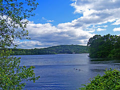
Titicus Reservoir
(c) Daniel Case, CC-BY-SA-3.0 Widok na zbiornik | |
| Położenie | |
| Państwo | |
|---|---|
| Stan | |
| Wysokość lustra | 99 m n.p.m. |
| Wyspy | 3 |
| Morfometria | |
| Powierzchnia | 681 akrów (2,76 km2) |
| Głębokość • średnia • maksymalna | 9,8 m 18 m |
| Objętość | 7 200 000 galonów amerykańskich (27 000 m3) |
| Hydrologia | |
| Rzeki zasilające | Titicus (rzeka) |
| Rzeki wypływające | Titicus (rzeka) |
| Rodzaj jeziora | Zbiornik retencyjny |
Położenie na mapie stanu Nowy Jork (c) Karte: NordNordWest, Lizenz: Creative Commons by-sa-3.0 de | |
Titicus Reservoir – zbiornik retencyjny w stanie Nowy Jork, w hrabstwie Westchester, należący do sieci wodociągowej miasta Nowy Jork, utworzony na rzece Titicus poprzez wybudowanie zapory wodnej, oddany do użytku w 1893 r[1].
Powierzchnia zbiornika wynosi 681 akrów (2,76 km2), maksymalna głębia to 60 stóp (18 m); średnia zaś to 32 stopy (9,8 m). Lustro wody położone jest 325 stóp (99 m) n.p.m[2]. Zbiornik mieści 7 200 000 galonów amerykańskich (27 000 m3) wody[1].
Woda ze zbiornika wypływa poprzez rzekę Titicus, biegnąc do Muscoot Reservoir, a dalej do New Croton Reservoir[1].
Przypisy
- ↑ a b c Titicus Reservoir, www1.nyc.gov [dostęp 2019-07-11] (ang.).
- ↑ Titicus Reservoir, www.dec.ny.gov [dostęp 2019-07-11] (ang.).
Media użyte na tej stronie
Autor: Uwe Dedering, Licencja: CC BY-SA 3.0
Relief location map of the USA (without Hawaii and Alaska).
EquiDistantConicProjection : Central parallel :
* N: 37.0° N
Central meridian :
* E: 96.0° W
Standard parallels:
* 1: 32.0° N
* 2: 42.0° N
Made with Natural Earth. Free vector and raster map data @ naturalearthdata.com.
Formulas for x and y:
x = 50.0 + 124.03149777329222 * ((1.9694462586094064-({{{2}}}* pi / 180))
      * sin(0.6010514667026994 * ({{{3}}} + 96) * pi / 180))
y = 50.0 + 1.6155950752393982 * 124.03149777329222 * 0.02613325650382181
      - 1.6155950752393982  * 124.03149777329222 *
     (1.3236744353715044  - (1.9694462586094064-({{{2}}}* pi / 180))
      * cos(0.6010514667026994 * ({{{3}}} + 96) * pi / 180))
The flag of Navassa Island is simply the United States flag. It does not have a "local" flag or "unofficial" flag; it is an uninhabited island. The version with a profile view was based on Flags of the World and as a fictional design has no status warranting a place on any Wiki. It was made up by a random person with no connection to the island, it has never flown on the island, and it has never received any sort of recognition or validation by any authority. The person quoted on that page has no authority to bestow a flag, "unofficial" or otherwise, on the island.
Autor: Tzugaj, Licencja: CC0
znak graficzny do map, ukazujący przykładowe jezioro
(c) Karte: NordNordWest, Lizenz: Creative Commons by-sa-3.0 de
Location map of New York, USA
(c) Daniel Case, CC-BY-SA-3.0
Photographed by Daniel Case 2006-06-10 on Route 116 near Purdy's.
Autor: Autor nie został podany w rozpoznawalny automatycznie sposób. Założono, że to Kmusser (w oparciu o szablon praw autorskich)., Licencja: CC BY-SA 3.0
This is a map of the Hudson River Watershed I made using USGS data, includes the Mohawk River.


