Tombigbee
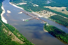
 Rzeka Tombigbee koło Coffeeville | |
| Kontynent | Ameryka Północna |
|---|---|
| Państwo | |
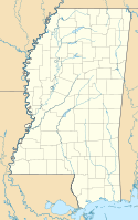
| Lokalizacja | Alabama, Missisipi |
| Rzeka | |
| Długość | 230 km |
| Powierzchnia zlewni | 54,6 tys. km² |
| Średni przepływ | 878,96[1] m³/s Gainesville |
| Źródło | |
| Miejsce | połączenie Black Warrior i Tennessee–Tombigbee Waterway Demopolis, Alabama |
| Wysokość | 38 m n.p.m. |
| Współrzędne | 34°25′58″N 88°25′15″W/34,432778 -88,420833 |
| Ujście | |
| Recypient | rzeka Mobile |
| Miejsce | na północ od miasta Mobile |
| Wysokość | 1 m n.p.m.[2] |
| Współrzędne | 31°08′11″N 87°56′39″W/31,136389 -87,944167 |
| Mapa | |
 | |
Tombigbee (ang. Tombigbee River) – rzeka w południowych USA, w stanach Alabama i Missisipi, o długości 230 km oraz powierzchni dorzecza 54 600 km². Źródła rzeki znajdują się w stanie Missisipi. Na terenie stanu Alabama łączy się z rzeką Alabama, dając początek rzece Mobile. Nazwa rzeki pochodzi od słów w języku Czoktawów[2].
Główne dopływy rzeki to Black Warrior, Sucarnoochee, Buttahatchee i Noxubee.
Większe miasta nad rzeką to Aberdeen, Columbus i Demopolis.
Rzeka Tombigbee jest wykorzystywana do produkcji energii elektrycznej oraz w żegludze.
Przypisy
- ↑ Tombigbee River, Station: Gainesville L&D NR Gainesville, AL (ang.). Global River Discharge Database. [dostęp 2014-12-29].
- ↑ a b Feature Detail Report for: Tombigbee River
Media użyte na tej stronie
Autor: Uwe Dedering, Licencja: CC BY-SA 3.0
Relief location map of the USA (without Hawaii and Alaska).
EquiDistantConicProjection : Central parallel :
* N: 37.0° N
Central meridian :
* E: 96.0° W
Standard parallels:
* 1: 32.0° N
* 2: 42.0° N
Made with Natural Earth. Free vector and raster map data @ naturalearthdata.com.
Formulas for x and y:
x = 50.0 + 124.03149777329222 * ((1.9694462586094064-({{{2}}}* pi / 180))
      * sin(0.6010514667026994 * ({{{3}}} + 96) * pi / 180))
y = 50.0 + 1.6155950752393982 * 124.03149777329222 * 0.02613325650382181
      - 1.6155950752393982  * 124.03149777329222 *
     (1.3236744353715044  - (1.9694462586094064-({{{2}}}* pi / 180))
      * cos(0.6010514667026994 * ({{{3}}} + 96) * pi / 180))
The flag of Navassa Island is simply the United States flag. It does not have a "local" flag or "unofficial" flag; it is an uninhabited island. The version with a profile view was based on Flags of the World and as a fictional design has no status warranting a place on any Wiki. It was made up by a random person with no connection to the island, it has never flown on the island, and it has never received any sort of recognition or validation by any authority. The person quoted on that page has no authority to bestow a flag, "unofficial" or otherwise, on the island.
Autor: Alexrk2, Licencja: CC BY 3.0
Ta mapa została stworzona za pomocą GeoTools.
Autor: Kmusser, Licencja: CC-BY-SA-3.0
Map showing the Tombigbee River, flowing from the State of Mississippi into Alabama, and joining the Alabama River. Other rivers include: the Tensaw River, Coosa River, Cahaba and Tallapoosa. Not pictured: Tennessee River and smaller rivers.
Autor: Alexrk2, Licencja: CC BY 3.0
Ta mapa została stworzona za pomocą GeoTools.
Aerial view of Coffeeville Lock and Dam on the Tombigbee River, spanning the border between Choctaw and Clarke Counties near Coffeeville, Alabama, USA. View is downriver to the east. The U.S. Army Corps of Engineers constructed the dam and lock on the river to provide a nine-foot navigation channel. Coffeeville Lock and Dam is the last lock and dam down the Tombigbee River (or the first, if travelling up the Tombigbee or Black Warrior River). There are no locks and dams between Coffeeville and the Gulf of Mexico.


