Tonle Sap (jezioro)
 | |
| Położenie | |
| Państwo | |
|---|---|
| Region | |
| Morfometria | |
| Powierzchnia | 2500–15 000 km² |
| Głębokość • maksymalna |
|
| Hydrologia | |
| Rzeki zasilające | |
| Rzeki wypływające | |
Położenie na mapie Kambodży  | |
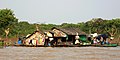
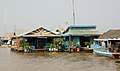
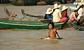
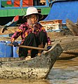
Tonle Sap – jezioro w Kambodży, w zachodniej części Niziny Kambodżańskiej; największe na Półwyspie Indochińskim. Bardzo zmienne pod względem stanu wody w zależności od pory roku; powierzchnia waha się od ok. 2,5 tys. w porze suchej do ok. 15 tys. km² w porze deszczowej[1]. Głębokość wynosi od 0,2 do 14 m[2]. Jezioro jest połączone przez rzekę Tônlé Sab z Mekongiem. Znajdują się na nim pływające wsie rybackie i liczne osiedla na palach.
Wkrótce po rozpoczęciu się pory deszczowej rzeka Tônlé Sab zmienia kierunek swego biegu i zaczyna płynąć wstecz, wtłaczając piętrzące się wody z Mekongu. Wówczas poziom wody jeziora gwałtownie się podnosi. Cofająca się rzeka Tônlé Sab nanosi do jeziora żyzne osady aluwialne; wpływają do niego również duże ilości ryb z Mekongu. W związku z tym jezioro jest jednym z najbardziej zasobnych w ryby słodkowodne akwenów na świecie. Roczne połowy wynoszą 170–210 tys. ton[3].
Galeria
- Tonlé Sap


Przypisy
- ↑ Eric Baran, Peter Starr, Yumiko Kura: Influence of built structures on Tonle Sap fisheries. Phnom Penh: Cambodia National Mekong Committee, 2007, s. 11. ISBN 978-983-2346-59-3.
- ↑ Fisheries in the Lower Mekong Basin: Review of the Fishery Sector in the Lower Mekong Basin. Bangkok: Interim Committee for Coordination of Investigations of the Lower Mekong Basin, 1992, s. 92.
- ↑ Thomas G. Northcote, G.F. Hartman: Fishes and forestry. Worldwide watershed interactions and management. Oxford: Blackwell Science, 2004, s. 621. ISBN 0-632-05809-9.
Media użyte na tej stronie


Autor: Tzugaj, Licencja: CC0
znak graficzny do map, ukazujący przykładowe jezioro

Autor: Gerd Eichmann, Licencja: CC BY-SA 4.0
Tonle Sap in Cambodia
Autor: Urutseg, Licencja: CC0
Map of Cambodia, parameters equivalent to File:Cambodia_location_map.svg

Autor: Gerd Eichmann, Licencja: CC BY-SA 4.0
Tonle Sap in Cambodia

Autor: Gerd Eichmann, Licencja: CC BY-SA 4.0
Tonle Sap in Cambodia

Autor: Gerd Eichmann, Licencja: CC BY-SA 4.0
Tonle Sap in Cambodia

Autor: Gerd Eichmann, Licencja: CC BY-SA 4.0
Tonle Sap in Cambodia

Autor: Gerd Eichmann, Licencja: CC BY-SA 4.0
Tonle Sap in Cambodia

Autor: Gerd Eichmann, Licencja: CC BY-SA 4.0
Tonle Sap in Cambodia

Autor: Gerd Eichmann, Licencja: CC BY-SA 4.0
Tonle Sap in Cambodia
The Tonle Sap (also know as the Great Lake) occupies a depression in the Cambodian Plain and is a shallow silt-laden lake. It is the largest lake in Southeast Asia and is fed by many streams. The Tonle Sap is drained by the Tonle Sab River (upper center), which flows south-southeast to the Mekong River (not visible on the image). The river connecting the Tonle Sap with the Mekong creates a unique phenomenon not known in any other part of the world: reversing its direction of flow twice a year. For most of the time, the Tonle Sab River flows from the lake to the Mekong River near the capital city of Phnom Penh. However, during the Southeast Asian monsoon season from June to November, when the Mekong drains large areas of Southeast Asia, the Tonle Sab flows from the Mekong back into the Tonle Sap. During the monsoon season, the Tonle Sap increases from 1000 sq. miles (2600 sq. km) to near 4020 sq. miles (10400 sq. km) raising the lake level 30 feet (9 meters), causing enormous floods in the region surrounding the lake.