Totteridge and Whetstone
 Budynek stacji | |
| Państwo | |
|---|---|
| Kraj | |
| Miejscowość | Londyn |
| Data otwarcia | 1872 |
| Northern Line | |
| Poprzednia stacja | High Barnet |
| Następna stacja | Woodside Park |
Położenie na mapie gminy Barnet  Contains Ordnance Survey data © Crown copyright and database right, CC BY-SA 3.0 | |
Położenie na mapie Wielkiej Brytanii  (c) Karte: NordNordWest, Lizenz: Creative Commons by-sa-3.0 de | |
Położenie na mapie Anglii  | |
Położenie na mapie Wielkiego Londynu  Contains Ordnance Survey data © Crown copyright and database right, CC BY-SA 3.0 | |
| Portal | |
Totteridge and Whetstone - naziemna stacja metra londyńskiego położona w dzielnicy Barnet. Leży na trasie jednego z północnych odgałęzień Northern Line. Stacja powstała w 1872 jako część sieci kolejowej. W 1940 przejęło ją metro[1]. Obecnie korzysta z niej ok. 1,65 mln pasażerów rocznie[2]. Należy do czwartej strefy biletowej[3].
 (c) Londoneye, CC-BY-SA-3.0
Przypisy
- ↑ Northern Line w serwisie Clive's UndergrounD Line Guides [dostęp 2010-11-24]
- ↑ Transport for London [dostęp 26.08.2008]
- ↑ Lista stacji i stref biletowych metra londyńskiego [dostęp 2010-11-24]
| Odgałęzienie High Barnet | |
|---|---|
| Odgałęzienie Edgware | |
| Odgałęzienie Charing Cross | |
| Odgałęzienie Bank | |
| Odgałęzienie Morden |
![]()
Media użyte na tej stronie
United Kingdom adm location map.svg
(c) Karte: NordNordWest, Lizenz: Creative Commons by-sa-3.0 de
Location map of the United Kingdom
(c) Karte: NordNordWest, Lizenz: Creative Commons by-sa-3.0 de
Location map of the United Kingdom
Greater London UK location map 2.svg
Contains Ordnance Survey data © Crown copyright and database right, CC BY-SA 3.0
Contains Ordnance Survey data © Crown copyright and database right, CC BY-SA 3.0
Map of Greater London, UK with the following information shown:
- Administrative borders
- Coastline, lakes and rivers
- Roads and railways
- Urban areas
The data includes both primary routes and railway lines.
Equirectangular map projection on WGS 84 datum, with N/S stretched 160%
Geographic limits:
- West: 0.57W
- East: 0.37E
- North: 51.72N
- South: 51.25N


Flag of England.svg
Flag of England. Saint George's cross (a red cross on a white background), used as the Flag of England, the Italian city of Genoa and various other places.
Flag of England. Saint George's cross (a red cross on a white background), used as the Flag of England, the Italian city of Genoa and various other places.

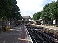
Totteridge & Whetstone stn northbound.JPG
Autor: Sunil060902, Licencja: CC BY-SA 3.0
Totteridge & Whetstone tube station looking north
Autor: Sunil060902, Licencja: CC BY-SA 3.0
Totteridge & Whetstone tube station looking north


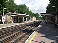
Totteridge & Whetstone stn southbound.JPG
Autor: Sunil060902, Licencja: CC BY-SA 3.0
Totteridge & Whetstone tube station looking south
Autor: Sunil060902, Licencja: CC BY-SA 3.0
Totteridge & Whetstone tube station looking south

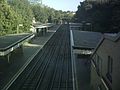
Totteridge platforms.jpg
(c) Londoneye, CC-BY-SA-3.0
The platforms at Totteridge and Whetstone tube station. Taken through the window from the entrance hall
(c) Londoneye, CC-BY-SA-3.0
The platforms at Totteridge and Whetstone tube station. Taken through the window from the entrance hall
Barnet London UK blank ward map.svg
Contains Ordnance Survey data © Crown copyright and database right, CC BY-SA 3.0
Contains Ordnance Survey data © Crown copyright and database right, CC BY-SA 3.0
Blank map of the London Borough of Barnet, showing electoral wards.
Equirectangular map projection on WGS 84 datum, with N/S stretched 160%
Geographic limits:
- West: 0.32W
- East: 0.12W
- North: 51.68N
- South: 51.54N