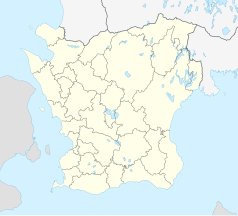
Trelleborg
 | |||
| |||
| Państwo | |||
|---|---|---|---|
| Region | |||
| Gmina | |||
| Powierzchnia | 15,77[1] km² | ||
| Populacja (2018) • liczba ludności • gęstość | |||
| Nr kierunkowy | 0410 | ||
| Kod pocztowy | 231 XX | ||
| Strona internetowa | |||
| Portal | |||
Trelleborg – miasto w południowej Szwecji. Siedziba władz administracyjnych gminy Trelleborg w regionie Skania, port nad Morzem Bałtyckim. Około 25 643 mieszkańców[2].
Trelleborg jest jednym z największych portów promowych, przewozów Ro-ro i przewozów intermodalnych w całej Skandynawii. Współczesna historia portu sięga 1902, gdy zawinął tam pierwszy statek ro-pax, kursujący na linii z Trelleborga do niemieckiego Sassnitz. Rocznie obsługuje ponad 2 miliony pasażerów oraz ponad pół miliona samochodów ciężarowych. Ponad 30 regularnych zawinięć promów powoduje, że tamtejszy port uznawany jest za główny węzeł komunikacyjny łączący Skandynawię z Centralną Europą. W mieście rozwinął się przemysł chemiczny oraz maszynowy[3].
Terminal w Trelleborgu obsługuje połączenia:
| Linia | Armator/operator | Czas podróży |
|---|---|---|
| Trelleborg – Rostock | Scandlines TT-Line | 5 godz. |
| Trelleborg – Sassnitz-Neu Mukran | Scandlines | 3.5 godz. |
| Trelleborg – Świnoujście | Unity Line TT-Line | 7 godz. |
| Trelleborg – Travemünde | TT-Line | 7 godz. |
Od 5 lutego 2007 ma połączenie promowe ze Świnoujściem.
Sport
- Trelleborgs FF – klub piłkarski
Współpraca zagraniczna
Miastem partnerskim Trelleborga jest miasto Stralsund w Niemczech.
Zobacz też
Przypisy
- ↑ a b c Statistiska tätorter 2018; befolkning, landareal, befolkningstäthet. Statistikmyndigheten SCB, 2020-03-20. [dostęp 2020-09-08]. [zarchiwizowane z tego adresu (2020-03-24)]. (szw.).
- ↑ Szwedzki Urząd Statystyczny SCB (szw.).
- ↑ Trelleborg, [w:] Encyklopedia PWN [online] [dostęp 2021-08-22].
Media użyte na tej stronie
Autor: Erik Frohne, Licencja: CC BY 3.0
Location map of Scania (Skåne) in Sweden
Equirectangular projection, N/S stretching 179 %. Geographic limits of the map:
- N: 56° 37' N
- S: 55° 12' N
- W: 12° 12' E
- E: 15° 00' E
Autor: Klugschnacker, Licencja: CC BY-SA 3.0
Trelleborg, Seeschlangen-Springbrunnen ("Sjöormsfontanen", 1935) und Turm
(c) Lokal_Profil, CC BY-SA 2.5
This coat of arms was drawn based on its blazon which – being a written description – is free from copyright. Any illustration conforming with the blazon of the arms is considered to be heraldically correct. Thus several different artistic interpretations of the same coat of arms can exist. The design officially used by the armiger is likely protected by copyright, in which case it cannot be used here.
Individual representations of a coat of arms, drawn from a blazon, may have a copyright belonging to the artist, but are not necessarily derivative works.


