Trenton
| ||||
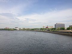
 Trenton z perspektywy rzeki Delaware | ||||
| ||||
| Przydomek: Capitol City, Turning Point of the Revolution. | ||||
| Państwo | ||||
|---|---|---|---|---|
| Stan | ||||
| Hrabstwo | ||||
| Prawa miejskie | 1792 | |||
| Zarządzający | Eric Jackson | |||
| Powierzchnia | 21,1 km² | |||
| Wysokość | 16 m n.p.m. | |||
| Populacja (2010) • liczba ludności • gęstość |
| |||
| Nr kierunkowy | 609 | |||
| Kod pocztowy | Lista kodów: | |||
| Strefa czasowa | ||||
| Strona internetowa | ||||
| Portal | ||||
Trenton – miasto w Stanach Zjednoczonych, stolica stanu New Jersey, nad rzeką Delaware.
Różnorodny przemysł, m.in.: maszynowy, gumowy (od 1852 fabryki Goodyear Tire i Rubber Company), elektrotechniczny, metalowy, materiałów budowlanych, włókienniczy, hutnictwo żelaza; ważny ośrodek handlowy; węzeł kolejowy i drogowy; stanowe centrum kulturalne z muzeum, planetarium, audytorium oraz biblioteką; port dostępny dla statków morskich, liczne zabytki z XVIII i XIX wieku.
Demografia
Szkolnictwo
Uczelnie
- Thomas Edison State College
- Mercer County Community College
Bibliografia
- CenStats Databases (ang.)
- Trenton, New Jersey. dmoztools.net. [zarchiwizowane z tego adresu (2020-09-24)]., Open Directory Project
Linki zewnętrzne
- Trenton w bazie city-data.com (ang.)
- Trenton Historical Society (ang.)
Przypisy
- ↑ Trenton (city), New Jersey. United States Census Bureau. [dostęp 2016-01-08]. (ang.).
Media użyte na tej stronie
Autor: Uwe Dedering, Licencja: CC BY-SA 3.0
Location map of the USA (without Hawaii and Alaska).
EquiDistantConicProjection:
Central parallel:
* N: 37.0° N
Central meridian:
* E: 96.0° W
Standard parallels:
* 1: 32.0° N
* 2: 42.0° N
Made with Natural Earth. Free vector and raster map data @ naturalearthdata.com.
Formulas for x and y:
x = 50.0 + 124.03149777329222 * ((1.9694462586094064-({{{2}}}* pi / 180))
      * sin(0.6010514667026994 * ({{{3}}} + 96) * pi / 180))
y = 50.0 + 1.6155950752393982 * 124.03149777329222 * 0.02613325650382181
      - 1.6155950752393982  * 124.03149777329222 *
     (1.3236744353715044  - (1.9694462586094064-({{{2}}}* pi / 180))
      * cos(0.6010514667026994 * ({{{3}}} + 96) * pi / 180))
The flag of Navassa Island is simply the United States flag. It does not have a "local" flag or "unofficial" flag; it is an uninhabited island. The version with a profile view was based on Flags of the World and as a fictional design has no status warranting a place on any Wiki. It was made up by a random person with no connection to the island, it has never flown on the island, and it has never received any sort of recognition or validation by any authority. The person quoted on that page has no authority to bestow a flag, "unofficial" or otherwise, on the island.
Flag of en:Trenton, New Jersey. Image created by uploader based on previous raster image and other images found on the web.
Opis
Courtesy of User:68.39.174.238, the New Jersey State House. BD2412 T 21:19, 14 June 2006 (UTC)
Licencja
| Ja, właściciel praw autorskich do tej pracy, udostępniam ją jako własność publiczną. Dotyczy to całego świata. W niektórych krajach może nie być to prawnie możliwe, jeśli tak, to: Zapewniam każdemu prawo do użycia tej pracy w dowolnym celu, bez żadnych ograniczeń, chyba że te ograniczenia są wymagane przez prawo. |
Autor: Alexrk, Licencja: CC BY 3.0
Ta mapa została stworzona za pomocą GeoTools.
Autor: Famartin, Licencja: CC BY-SA 3.0
View of downtown Trenton, New Jersey from the Trenton Makes Bridge


