Tripura
| stan | |
 | |
| Państwo | |
|---|---|
| Siedziba | Agartala |
| Kod ISO 3166-2 | IN-TR |
| Gubernator | Dinesh Nandan Sahay |
| Powierzchnia | 10 492 km² |
| Populacja (2011) • liczba ludności | 3 671 032[1] |
| • gęstość | 349,9 os./km² |
| Języki urzędowe | bengalski |
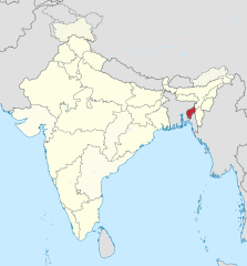
Położenie na mapie Indii | |
| Strona internetowa | |
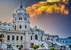
Tripura (hindi त्रिपुरा, trb.: Tripura, trl.: Tripurā; bengalski ত্রিপুরা; ang. Tripura) – jeden ze stanów Indii, położony w ich północno-wschodniej części. Stolicą stanu, a zarazem największym miastem jest Agartala. Stan został utworzony 21 stycznia 1972 roku.
Podział administracyjny
Stan Tripura dzieli się na następujące okręgi:
- Dhalai
- Tripura Południowa
- Tripura Wschodnia
- Tripura Zachodnia
Przypisy
- ↑ 3. Size, Growth Rate and Distribution of Population, [w:] 2011 Census of India, Office of the Registrar General & Census Commissioner, India [dostęp 2019-08-02] [zarchiwizowane z adresu 2019-05-31].
Media użyte na tej stronie
The Flag of India. The colours are saffron, white and green. The navy blue wheel in the center of the flag has a diameter approximately the width of the white band and is called Ashoka's Dharma Chakra, with 24 spokes (after Ashoka, the Great). Each spoke depicts one hour of the day, portraying the prevalence of righteousness all 24 hours of it.
Autor: Sharada Prasad CS, Licencja: CC BY 2.0
Buildings
Autor: TUBS
Location of state XY (see filename) in India


