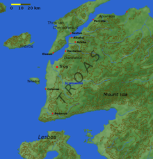
Troada

Troada (Troas) – starożytna kraina w Azji Mniejszej w północno-zachodniej Anatolii, pomiędzy Morzem Egejskim a Hellespontem i rzeką Ajespos (według Strabona). Od reszty Anatolli jest oddzielona masywem góry Ida (tur. Kazdağı). Obecnie region ten jest częścią tureckiej prowincji Çanakkale, gdzie znajduje się m.in. stanowisko archeologiczne z ruinami starożytnej Troi.
Główne miasta – Troja (Ilion) i Lampsakos, główna rzeka – Skamander.
Media użyte na tej stronie
Autor:
Dbachmann z angielskiej Wikipedii
Later versions were uploaded by Joy at en.wikipedia., Licencja: CC-BY-SA-3.0Map of the Troad, including the site of Troy. Note that the modern coastline has been altered to show a bay at the mouth of Scamander where the Greek ships would have been.
Picture of a map of the region of what is now Turkey from the 15th Century. I own this map, having purchased it, and have all official documentation regarding its authenticity.


