Trona
| ||||
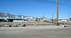
 Zabudowania przemysłowe w centrum osady Trona | ||||
| Państwo | ||||
|---|---|---|---|---|
| Stan | ||||
| Hrabstwo | Inyo | |||
| Populacja • liczba ludności | 18, 11, 11 | |||
| Nr kierunkowy | 760 | |||
| Kod pocztowy | 93562 | |||
| Strefa czasowa | UTC-08:00 UTC-07:00 | |||
| Portal | ||||
Trona – census-designated place w stanie Kalifornia, w hrabstwie Inyo. Liczba mieszkańców 1 885 (2000).
Położenie
Osada położona jest w odległości ok. 270 km na północny wschód od Los Angeles. Położona jest na brzegu wyschniętego jeziora Searles Lake.
Historia
Trona została założona w 1913 roku jako pustynna, górnicza osada, której podstawą było wydobycie boraksu. Dochodzi do niej linia kolejowa, która została zbudowana w latach 1913-1914. Do dziś w gospodarce osady dominuje przemysł wydobywczy, zwłaszcza boraksu, węglanu sodu, siarczanu sodu i innych soli.
Linki zewnętrzne
Media użyte na tej stronie
Autor: NordNordWest, Licencja: CC BY 3.0
Location map of California, USA
Autor: Uwe Dedering, Licencja: CC BY-SA 3.0
Location map of the USA (without Hawaii and Alaska).
EquiDistantConicProjection:
Central parallel:
* N: 37.0° N
Central meridian:
* E: 96.0° W
Standard parallels:
* 1: 32.0° N
* 2: 42.0° N
Made with Natural Earth. Free vector and raster map data @ naturalearthdata.com.
Formulas for x and y:
x = 50.0 + 124.03149777329222 * ((1.9694462586094064-({{{2}}}* pi / 180))
      * sin(0.6010514667026994 * ({{{3}}} + 96) * pi / 180))
y = 50.0 + 1.6155950752393982 * 124.03149777329222 * 0.02613325650382181
      - 1.6155950752393982  * 124.03149777329222 *
     (1.3236744353715044  - (1.9694462586094064-({{{2}}}* pi / 180))
      * cos(0.6010514667026994 * ({{{3}}} + 96) * pi / 180))
The flag of Navassa Island is simply the United States flag. It does not have a "local" flag or "unofficial" flag; it is an uninhabited island. The version with a profile view was based on Flags of the World and as a fictional design has no status warranting a place on any Wiki. It was made up by a random person with no connection to the island, it has never flown on the island, and it has never received any sort of recognition or validation by any authority. The person quoted on that page has no authority to bestow a flag, "unofficial" or otherwise, on the island.
Autor: Bobak Ha'Eri, Licencja: CC BY-SA 2.5
Soda Ash plant dominates downtown (In the picture above is not the soda ash plant but the Trona Facility, which mines boron products. The soda ash plant is located in the Argus Facility.) Trona, California.
Flag of California. This version is designed to accurately depict the standard print of the bear as well as adhere to the official flag code regarding the size, position and proportion of the bear, the colors of the flag, and the position and size of the star.


