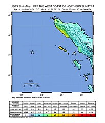
Trzęsienie ziemi na Oceanie Indyjskim (2012)
| ||
 | ||
| Nawiedzone państwa | ||
| Data | 11 kwietnia 2012 | |
| Godzina | 15:38:37 | |
| Ofiary śmiertelne | 10 osób[1] | |
| Ranni | 1 osoba | |
| Magnituda | 8,6 | |
Trzęsienie ziemi na Oceanie Indyjskim – trzęsienie ziemi o magnitudzie 8,6, które nawiedziło okręg Aceh w Indonezji 11 kwietnia 2012 roku o godzinie 15:38 czasu miejscowego; jego epicentrum znajdowało się 500 km na południowy zachód od Banda Aceh, a hipocentrum na głębokości 22 km. Główne miasto objęte trzęsieniem ziemi to Banda Aceh. Fala tsunami, która nawiedziła Simeulue, miała od 40 do 50 cm wysokości.
Skutki
Kilkadziesiąt kilometrów od wybrzeży Sumatry woda cofnęła się o 10 m[2].
Rząd Tajlandii ewakuował mieszkańców wybrzeża Andamańskiego[3].
Zobacz też
Przypisy
- ↑ CNN: 5 die after earthquake near Indonesia (ang.). [dostęp 2012-04-12].
- ↑ Odwołali alarm przed tsunami. Fale miały metr wysokości.
- ↑ Trzęsienie ziemi na Oceanie Indyjskim. Ewakuacja Tajlandii.
Media użyte na tej stronie
bendera Indonesia
The Flag of India. The colours are saffron, white and green. The navy blue wheel in the center of the flag has a diameter approximately the width of the white band and is called Ashoka's Dharma Chakra, with 24 spokes (after Ashoka, the Great). Each spoke depicts one hour of the day, portraying the prevalence of righteousness all 24 hours of it.
The national flag of Kingdom of Thailand since September 2017; there are total of 3 colours:
- Red represents the blood spilt to protect Thailand’s independence and often more simply described as representing the nation.
- White represents the religion of Buddhism, the predominant religion of the nation
- Blue represents the monarchy of the nation, which is recognised as the centre of Thai hearts.
Autor: Tentotwo, Licencja: CC BY-SA 3.0
Location map of the Indian Ocean.
- Projection: Lambert azimuthal equal-area projection.
- Area of interest:
- N: 30.0° N
- S: -70.0° N
- W: 30.0° E
- E: 150.0° E
- Projection center:
- NS: -20.0° N
- WE: 90.0° E
- GMT projection: -JA90.0/-20.0/180/19.998266666666666c
- GMT region: -R-12.856058461183775/-43.848273739920856/151.50519408595028/33.22162400070504r
- Land and shoreline: 1:110m Natural Earth Datasets, borders 1:50m
Map of the 2012 April 11th earthquake off the coast of Aceh. Mag - 8.6
Autor: Mikenorton, Licencja: CC BY-SA 3.0
Bull's eye graphic for use with earthquake location maps


