Tsuruoka
| |||||||
 | |||||||
| Państwo | |||||||
|---|---|---|---|---|---|---|---|
| Prefektura | |||||||
| Wyspa | |||||||
| Region | |||||||
| Burmistrz | Osamu Minakawa | ||||||
| Powierzchnia | 1 311,53[1] km² | ||||||
| Populacja (2020) • liczba ludności • gęstość |
| ||||||
| Symbole japońskie | |||||||
| Drzewo | Fagus crenata | ||||||
| Kwiat | |||||||
| Strona internetowa | |||||||
| Portal | |||||||
Tsuruoka (jap. 鶴岡市 Tsuruoka-shi) – miasto w prefekturze Yamagata w Japonii (Honsiu), leży nad Morzem Japońskim. Ma powierzchnię 1 311,53 km2 [1]. W 2020 r. mieszkały w nim 122 454 osoby, w 45 780 gospodarstwach domowych[2] (w 2010 r. 136 627 osób, w 45 496 gospodarstwach domowych)[3].
Położenie
Miasto leży w środkowej części prefektury nad Morzem Japońskim. Graniczy z miastami:
oraz kilkoma miasteczkami.
Historia
Miasto powstało 1 kwietnia 1889 roku.
Miasta partnerskie
 Japonia: Kagoshima, Kikonai
 Stany Zjednoczone: New Brunswick
Przypisy
Bibliografia
- Geospatial Information Authority of Japan: 令和3年 全国都道府県市区町村別面積調 (1月1日時点) (Reiwa 3rd year Area adjustment by prefecture, city, ward, town, and village (As of January 1)). gsi.go.jp, 2021. [dostęp 2021-09-10]. [zarchiwizowane z tego adresu (2021-06-05)]. (jap.).
- Statistics Bureau, Ministry of Internal Affairs and Communications: Preliminary Counts of the Population and Households. [w:] 2020 Population Census [on-line]. e-stat.go.jp Portal Site of Official Statistics of Japan, 2021. [dostęp 2021-09-10]. (ang.).
- 平成22年国勢調査 – 人口速報集計結果 (2010 Census - Population Bulletin Aggregation Results). e-stat.go.jp Portal Site of Official Statistics of Japan, 2011. [dostęp 2021-09-10]. (jap.).
Media użyte na tej stronie
Autor: Maximilian Dörrbecker (Chumwa), Licencja: CC BY-SA 3.0
Location map of Japan
Equirectangular projection.
Geographic limits to locate objects in the main map with the main islands:
- N: 45°51'37" N (45.86°N)
- S: 30°01'13" N (30.02°N)
- W: 128°14'24" E (128.24°E)
- E: 149°16'13" E (149.27°E)
Geographic limits to locate objects in the side map with the Ryukyu Islands:
- N: 39°32'25" N (39.54°N)
- S: 23°42'36" N (23.71°N)
- W: 110°25'49" E (110.43°E)
- E: 131°26'25" E (131.44°E)
The flag of Navassa Island is simply the United States flag. It does not have a "local" flag or "unofficial" flag; it is an uninhabited island. The version with a profile view was based on Flags of the World and as a fictional design has no status warranting a place on any Wiki. It was made up by a random person with no connection to the island, it has never flown on the island, and it has never received any sort of recognition or validation by any authority. The person quoted on that page has no authority to bestow a flag, "unofficial" or otherwise, on the island.
Flag of Tsuruoka, Yamagata
Autor: Haseyu- z japońskiej Wikipedii, Licencja: CC-BY-SA-3.0
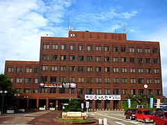
鶴岡市役所 山形県鶴岡市 2007年8月10日15:23


