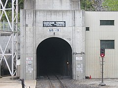
Tunel Gór Kaskadowych
| Państwo | |
|---|---|
| Przeszkoda | |
| Rodzaj | kolejowy |
| Długość | 7,8 m |
| Data otwarcia | 12 stycznia 1929 |
Tunel Gór Kaskadowych (ang. Cascade Tunnel) – tunel kolejowy w Górach Kaskadowych[1][2].
Historia
Pierwszy tunel gór kaskadowych został ukończony w 1900 roku[2]. Natomiast w 1909 roku został zelektryfikowany[2]. Obiekt miał długość 2,6 mili[3]. Nowy tunel kaskadowy został otwarty w dniu 12 stycznia 1929 roku[4]. Został poprowadzony pomiędzy miejscowościami Berne i Scenic[4]. Długość budowli wynosi 7,8 mili[5]. Natomiast w 1956 roku została zdemontowana elektryczna sieć trakcyjna w tunelu[2].
Przypisy
- ↑ Ameryka, [w:] Komisji Standaryzacji Nazw Geograficznych poza Granicami Rzeczypospolitej Polskiej, Nazewnictwo geograficzne świata, t. 1, Warszawa: Główny Urząd Geodezji i Kartografii, 2004, s. 87-94, ISBN 83-239-7552-3, OCLC 749424443.
- ↑ a b c d Steve Glischinski, Making Great Northern great, „Trains”, 79 (1), Waukesha: Kalmbach Media, 2019, s. 36-43, ISSN 0041-0934, OCLC 45652638 (ang.).
- ↑ Great Northern Railway Company, Annual report of the Great Northern Railway Company., t. 55, Saint Paul: Great Northern Railway Company, 1943, s. 20-21, OCLC 1751554 (ang.).
- ↑ a b L.H. Burnham, Ventilation of Electric Locomotives for Tunnel Service : New Cascade Tunnel -Great Northern Railway, „Ohio State Engineer”, 16 (4), Columbus: Uniwersytet Stanowy Ohio, luty 1933, s. 9, OCLC 31451877 (ang.).
- ↑ The Roots of Decline, [w:] Christian Wolmar, The Great Railroad Revolution: The History of Trains in America, Londyn: Atlantic Books, 2012, s. 310, ISBN 978-0-8021-9813-6, LCCN 2012020987, OCLC 937824027 (ang.).
Bibliografia
Media użyte na tej stronie
Autor: Uwe Dedering, Licencja: CC BY-SA 3.0
Location map of the USA (without Hawaii and Alaska).
EquiDistantConicProjection:
Central parallel:
* N: 37.0° N
Central meridian:
* E: 96.0° W
Standard parallels:
* 1: 32.0° N
* 2: 42.0° N
Made with Natural Earth. Free vector and raster map data @ naturalearthdata.com.
Formulas for x and y:
x = 50.0 + 124.03149777329222 * ((1.9694462586094064-({{{2}}}* pi / 180))
      * sin(0.6010514667026994 * ({{{3}}} + 96) * pi / 180))
y = 50.0 + 1.6155950752393982 * 124.03149777329222 * 0.02613325650382181
      - 1.6155950752393982  * 124.03149777329222 *
     (1.3236744353715044  - (1.9694462586094064-({{{2}}}* pi / 180))
      * cos(0.6010514667026994 * ({{{3}}} + 96) * pi / 180))
The flag of Navassa Island is simply the United States flag. It does not have a "local" flag or "unofficial" flag; it is an uninhabited island. The version with a profile view was based on Flags of the World and as a fictional design has no status warranting a place on any Wiki. It was made up by a random person with no connection to the island, it has never flown on the island, and it has never received any sort of recognition or validation by any authority. The person quoted on that page has no authority to bestow a flag, "unofficial" or otherwise, on the island.
(c) Sturmovik z angielskiej Wikipedii, CC BY-SA 3.0
Eastern portal of the BNSF Cascade Tunnel located at Milepost 1700 on the Scenic Subdivision. The 7.5 mile long railroad tunnel is the longest in the United States. The eastern portal is the site of the 1600hp fan plant that scrubs the tunnel of diesel exhaust fumes after each train passes through.


