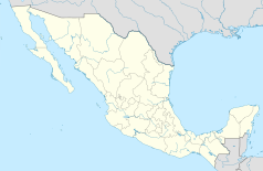
Tuxtla Gutiérrez
 | |||
| |||
| Państwo | |||
|---|---|---|---|
| Stan | |||
| Gmina | Tuxtla Gutiérrez | ||
| Data założenia | 1560 (Fray Antonio de Pamplona) | ||
| Zarządzający | Samuel Toledo Córdova, PRI | ||
| Powierzchnia | 412,4 km² | ||
| Wysokość | 520-1160 m n.p.m. | ||
| Populacja (2010) • liczba ludności |
| ||
| Nr kierunkowy | 961 | ||
| Kod pocztowy | 29000-29112 | ||
| Tablice rejestracyjne | 7 | ||
| Strona internetowa | |||
Tuxtla Gutiérrez – miasto w południowo-wschodnim Meksyku, na przedgórzu Sierra Madre de Chiapas, przy Drodze Panamerykańskiej, stolica i największe miasto stanu Chiapas. W 2010 roku zamieszkane przez 537 102 osób[1].
Miasta partnerskie
 Puebla, Meksyk
 Celaya, Meksyk
 Zamora de Hidalgo, Meksyk
 Pachuca, Meksyk
 Coatzacoalcos, Meksyk
 Amarillo, Stany Zjednoczone
Przypisy
- ↑ a b Censo de Población y Vivienda 2010, Principales Resultados por Localidad. Instituto Nacional de Estadística, Geografía e Informática. [dostęp 2014-04-18]. (hiszp.).
Media użyte na tej stronie
The flag of Navassa Island is simply the United States flag. It does not have a "local" flag or "unofficial" flag; it is an uninhabited island. The version with a profile view was based on Flags of the World and as a fictional design has no status warranting a place on any Wiki. It was made up by a random person with no connection to the island, it has never flown on the island, and it has never received any sort of recognition or validation by any authority. The person quoted on that page has no authority to bestow a flag, "unofficial" or otherwise, on the island.
Coat of arms of Chiapas


