Tyne
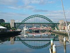
 Most nad rzeką Tyne | |
| Kontynent | |
|---|---|
| Państwo | |
| Kraj | |
| Lokalizacja | hrabstwa Northumberland i Tyne and Wear |
| Rzeka | |
| Długość | 100 km |
| Źródło | |
| Miejsce | zbieg rzek North Tyne i South Tyne, koło Hexham |
| Współrzędne | |
| Ujście | |
| Recypient | |
| Miejsce | między Tynemouth a South Shields |
| Współrzędne | |
Położenie na mapie Northumberland Contains Ordnance Survey data © Crown copyright and database right, CC BY-SA 3.0 | |
Tyne – rzeka w Wielkiej Brytanii o długości ok. 100 km[1]. Uchodzi do Morza Północnego[1], w dolnym biegu dostępna jest dla statków morskich.
Główne miasto położone nad rzeką to Newcastle upon Tyne[1].
Przypisy
- ↑ a b c Tyne, [w:] Encyklopedia PWN [online] [dostęp 2020-08-02].
Media użyte na tej stronie
Autor: Alexrk2, Licencja: CC BY-SA 3.0
Location map of the United Kingdom
Flag of England. Saint George's cross (a red cross on a white background), used as the Flag of England, the Italian city of Genoa and various other places.
Contains Ordnance Survey data © Crown copyright and database right, CC BY-SA 3.0
Relief map of Northumberland, UK.
Equirectangular map projection on WGS 84 datum, with N/S stretched 170%
Geographic limits:
- West: 2.85W
- East: 1.35W
- North: 55.83N
- South: 54.77N
Autor: Nilfanion, Licencja: CC BY-SA 3.0
Relief map of England, UK.
Equirectangular map projection on WGS 84 datum, with N/S stretched 170%
Geographic limits:
- West: 6.75W
- East: 2.0E
- North: 56.0N
- South: 49.75N
Autor: Tagishsimon, Licencja: CC BY-SA 3.0
The Tyne Bridge across the River Tyne between Newcastle upon Tyne and Gateshead. Taken from the deck of the Gateshead Millennium Bridge, looking west.
The Tyne Bridge is the compression arch bridge in green. Below and behind it is the Swing Bridge, in red. Behind that, in grey, is the High Level Bridge. Behind that is the w:Queen Elizabeth II Metro Bridge. You can just about see the pillars of the King Edward VII Bridge, which carries the mainline railway across the river into Newcastle Central station; and, I assure you, the Redheugh Bridge (a modern road bridge) is hidden behind them all.
The boats on the Gateshead shore are the Archer class patrol vessels of the HMS Calliope shore establishment, and the permanently moored Tuxedo Princess floating nightclub (the former car ferry TSS Caledonian Princess).
This photo appears to have been taken from the Tyne's easternmost bridge, the low-level, swivelling, pedestrian Millenium Bridge.


