Tyne and Wear
| Hrabstwo ceremonialne i metropolitalne | |||
 Gateshead Millenium Bridge nad rzeką Tyne | |||
| |||
| Państwo | |||
|---|---|---|---|
| Kraj | |||
| Region | |||
| Siedziba | brak | ||
| Powierzchnia | 540 km²[1] | ||
| Populacja (2016) • liczba ludności |
| ||
| • gęstość | 2090 os./km² | ||
| Szczegółowy podział administracyjny | |||
 | |||
| Liczba dystryktów | 5 | ||
Położenie na mapie | |||
| Portal | |||
Tyne and Wear – hrabstwo ceremonialne i metropolitalne w północno-wschodniej Anglii, w regionie North East England, położone nad ujściami rzek Tyne i Wear do Morza Północnego. Hrabstwo obejmuje obszar metropolitalny nad ujściami rzek Tyne i Wear do Morza Północnego, w tym konurbację Tyneside. Utworzone zostało w 1974 roku na pograniczu historycznych hrabstw Northumberland i Durham.
Powierzchnia hrabstwa wynosi 540 km², a liczba ludności – 1 128 757 (2016)[1]. Największym miastem hrabstwa jest Newcastle upon Tyne, który do czasu likwidacji rady hrabstwa w 1986 roku był ośrodkiem administracyjnym. Dwa miasta w hrabstwie posiadają status city – Newcastle oraz Sunderland. Innymi większymi miastami Tyne and Wear są Tynemouth, South Shields, Gateshead oraz Washington.
Na północy Tyne and Wear graniczy z hrabstwem Northumberland a na południu z Durham.
Podział administracyjny
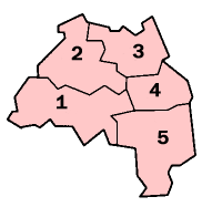
W skład hrabstwa wchodzi pięć dystryktów.
Mapa
Uwagi
- ↑ Do czasu likwidacji rady hrabstwa
Przypisy
- ↑ a b c MYE5: Population estimates: Population density for the local authorities in the UK, mid-2001 to mid-2016, [w:] Population Estimates for UK, England and Wales, Scotland and Northern Ireland – Mid-2016 [online], Office for National Statistics [dostęp 2017-10-21] (ang.).
- ↑ Office for National Statistics: KS101EW - Usual resident population. [w:] 2011 Census [on-line]. Nomis – Official labour market statistics, 2013-02-12. [dostęp 2022-06-05]. (ang.).
- ↑ Office for National Statistics: Built-up Area to Local Authority District (December 2011) Lookup in England and Wales. [w:] Open Geography Portal [on-line]. [dostęp 2022-06-05]. (ang.).
- ↑ Office for National Statistics: Built-up Area Sub Divisions (December 2011) Boundaries. [w:] Open Geography Potal [on-line]. [dostęp 2022-06-05]. (ang.).
Bibliografia
- Tyne and Wear, [w:] Encyclopædia Britannica [online] [dostęp 2012-07-31] (ang.).
Media użyte na tej stronie
Flag of England. Saint George's cross (a red cross on a white background), used as the Flag of England, the Italian city of Genoa and various other places.
unofficial, Said to be the County Flag of Tyne & Wear, representing the metropolitan county of Tyne and Wear in North East England.
Autor: Nilfanion, Licencja: CC BY-SA 3.0
Location of the ceremonial county of Tyne and Wear within England.
Contains Ordnance Survey data © Crown copyright and database right, CC BY-SA 3.0
Map of Tyne and Wear, UK, with the following information shown:
- Administrative borders
- Coastline, lakes and rivers
- Roads and railways
- Urban areas
Equirectangular map projection on WGS 84 datum, with N/S stretched 170%
Geographic limits:
- West: 1.90W
- East: 1.30W
- North: 55.09N
- South: 54.78N


