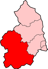
Tynedale
| dystrykt niemetropolitalny | |
(c) Kenneth Allen, CC BY-SA 2.0 | |
| Państwo | |
|---|---|
| Kraj | |
| Region | |
| Hrabstwo | |
| Populacja (2001) • liczba ludności |
|
Położenie na mapie Northumberland | |
| Portal | |
Tynedale – były dystrykt w hrabstwie Northumberland w Anglii. W 2001 roku dystrykt liczył 58 808 mieszkańców[1].
Civil parishes
- Acomb, Allendale, Bardon Mill, Bavington, Bellingham, Birtley, Blanchland, Broomhaugh and Riding, Broomley and Stocksfield, Bywell, Chollerton, Coanwood, Corbridge, Corsenside, Falstone, Featherstone, Greenhead, Greystead, Haltwhistle, Hartleyburn, Haydon, Healey, Hedley, Henshaw, Hexham, Hexhamshire, Hexhamshire Low Quarter, Horsley, Humshaugh, Kielder, Kirkwhelpington, Knaresdale with Kirkhaugh, Melkridge, Newbrough, Otterburn, Ovingham, Ovington, Plenmeller with Whitfield, Prudhoe, Rochester, Sandhoe, Shotley Low Quarter, Simonburn, Slaley, Tarset, Thirlwall, Wall, Warden, Wark, West Allen, Whittington i Wylam[2].
Przypisy
- ↑ Neighbourhood Statistics. [dostęp 2015-10-04]. [zarchiwizowane z tego adresu (2015-10-08)].
- ↑ w 2001. [dostęp 2015-10-04]. [zarchiwizowane z tego adresu (2015-10-08)].
Media użyte na tej stronie
Flag of England.svg
Flag of England. Saint George's cross (a red cross on a white background), used as the Flag of England, the Italian city of Genoa and various other places.
Flag of England. Saint George's cross (a red cross on a white background), used as the Flag of England, the Italian city of Genoa and various other places.
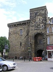
The Moot Hall, Hexham - geograph.org.uk - 187473.jpg
(c) Kenneth Allen, CC BY-SA 2.0
The Moot Hall, Hexham. A Moot hall is meeting or assembly place, traditionally to decide local issues
(c) Kenneth Allen, CC BY-SA 2.0
The Moot Hall, Hexham. A Moot hall is meeting or assembly place, traditionally to decide local issues


