Ubud
(c) っ, CC-BY-SA-3.0 Ubud (jedna z ulic w mieście) | |
| Państwo | |
|---|---|
| Prowincja | |
| Powierzchnia | 43.3 km² |
| Populacja (2010) • liczba ludności • gęstość |
|
Ubud – miasto na indonezyjskiej wyspie Bali w dystrykcie Ubud, położone wśród pól ryżowych i w stromych wąwozach w centralnej części podnóża regency Gianyar. Ubud liczy około 70 tys. mieszkańców.
Zabytki
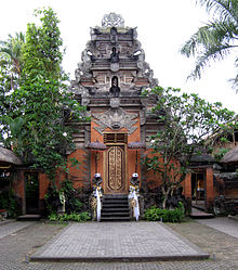
- Pałac Królewski (Puri Saren Agung) – wybudowany na początku XIX w. i odbudowany w 1917 r. po trzęsieniu ziemi.
- Muzeum Pura Lukisan – założone w 1956[1] roku w celu zachowania i popularyzacji sztuki balijskiej, zarówno tradycyjnej, jak i nowoczesnej.
Przypisy
- ↑ Praca zbiorowa: Podróże Marzeń – Indonezja. Wyd. I. Warszawa: Mediaprofit sp. z o.o., 2007, s. 217. ISBN 978-83-60174-66-1.
Media użyte na tej stronie
Autor: Uwe Dedering, Licencja: CC BY-SA 3.0
Location map of Indonesia.
Equirectangular projection. Stretched by 100.0%. Geographic limits of the map:
- N: 6.5° N
- S: -11.5° N
- W: 94.5° E
- E: 141.5° E
bendera Indonesia
Autor: alfaneque, Licencja: CC BY 2.0
This is a hindu temple into the rainforest in Ubud, Bali.
Autor: Michael Gunther, Licencja: CC BY-SA 4.0
Located in the center of the Ubud Palace district, Puri Saren Agung is the former palace of the rulers of Ubud, and the current home of some of their descendants. It was built in the early 19th century. Today, the non-residential parts of the compound have been repurposed into a tourist and cultural venue that includes a small hotel, shrines, gardens, pavilions (balés), and a performance stage.
The puri's entrance gate retains many traditional elements: three entrance doors, a gopuram (India)-style tower, guardian statues wrapped in honorific cloth, and a kala (India - monster mask) over the central door.


