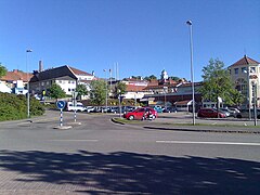
Ulricehamn
 | |||
| |||
| Państwo | |||
|---|---|---|---|
| Region | |||
| Gmina | Gmina Ulricehamn | ||
| Powierzchnia | 7,47[1] km² | ||
| Populacja (2018) • liczba ludności • gęstość | 11 333[1] 1517[1] os./km² | ||
| Kod pocztowy | 5104 | ||
| Strona internetowa | |||
| Portal | |||
Ulricehamn (daw. Bogesund) – miasto w Szwecji, siedziba władz administracyjnych gminy Ulricehamn w regionie Västra Götaland. Według danych z 31 grudnia 2005 r. miasto miało 9 250 mieszkańców[2].
Ulricehamn znajduje się 32 km na wschód od Borås i 49 km na zachód od Jönköping. Położone jest nad jeziorem Åsunden, do którego wpada rzeka Ätran.
Prawa miejskie otrzymało najpóźniej w XV wieku. W 1520 r. pod Ulricehamn rozegrała się bitwa pomiędzy armią króla Christiana II a oddziałami Stena Sture Młodszego[3]. Do 1741 r. nosiło nazywało się Bogesund. Nową nazwę nadano na cześć królowej Ulriki Eleonory.
Miasto uchodzi za bazę sportów zimowych zachodniej Szwecji. Znajduje się tu siedem wyciągów, sześć stoków oraz 210 km trasy biegowej.
Z Ulricehamn pochodzi biegaczka narciarska Hanna Falk.
Zobacz też
Przypisy
- ↑ a b c Statistiska tätorter 2018; befolkning, landareal, befolkningstäthet (szw.). Statistikmyndigheten SCB, 2020-03-20. [dostęp 2020-09-08]. [zarchiwizowane z tego adresu (2020-03-24)].
- ↑ Tätorter; arealer, befolkning (szw.). Szwedzki Urząd Statystyczny. [dostęp 2011-02-07].
- ↑ Lena Huldén, Sten Sture d.y., [w:] Biografiskt lexikon för Finland 1. Svenska tiden [online] [dostęp 2016-10-24] (szw.).
Media użyte na tej stronie
View towards east from Strandgatan in Ulricehamn.
Autor: Erik Frohne, Licencja: CC BY 3.0
Location map of Västra Götaland in Sweden
Equirectangular projection, N/S stretching 190 %. Geographic limits of the map:
- N: 59.50° N
- S: 57.10° N
- W: 10.90° E
- E: 15.20° E
(c) Lokal_Profil, CC BY-SA 2.5
This coat of arms was drawn based on its blazon which – being a written description – is free from copyright. Any illustration conforming with the blazon of the arms is considered to be heraldically correct. Thus several different artistic interpretations of the same coat of arms can exist. The design officially used by the armiger is likely protected by copyright, in which case it cannot be used here.
Individual representations of a coat of arms, drawn from a blazon, may have a copyright belonging to the artist, but are not necessarily derivative works.


