Ulva
(c) Mick Garratt, CC BY-SA 2.0 | |
| Kontynent | |
|---|---|
| Państwo | |
| Akwen | |
| Archipelag | |
| Populacja (2001) • liczba ludności |
|
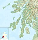
Położenie na mapie Argyll and Bute Contains Ordnance Survey data © Crown copyright and database right, CC BY-SA 3.0 | |
Położenie na mapie Szkocji | |
Ulva lub Isle of Ulva, gael. Ulbha) – wyspa w archipelagu Hebrydów (Hebrydy Wewnętrzne), wchodząca w skład Wysp Brytyjskich, oddzielona od Wielkiej Brytanii.
Linki zewnętrzne
- The Isle of Ulva "A world apart". ulva.mull.com. [zarchiwizowane z tego adresu (2007-10-10)].
- Now who be ye, would cross Loch Gyle? (Ulva) John Hannavy visits Ulva, a tiny island off the west coast of Mull Published in Scotland Magazine Issue 31 on 16/02/2007. scotlandmag.com. [zarchiwizowane z tego adresu (2007-11-07)].
- Mullmagic.com Isle of Ulva. mullmagic.com. [zarchiwizowane z tego adresu (2011-07-14)].
- Images of archaeological sites in Mull and Ulva, Clive Ruggles, University of Leicester.
Media użyte na tej stronie
Autor: Alexrk2, Licencja: CC BY-SA 3.0
Location map of the United Kingdom
(c) Eric Gaba, NordNordWest, Uwe Dedering, CC BY-SA 3.0
Location map of Scotland, United Kingdom
(c) Mick Garratt, CC BY-SA 2.0
"Bluebells, Ulva. I'd always thought bluebells were a woodland species but certainly in this part of Scotland they bask in profusion in the May sunshine. Taking advantage before the bracken grows." Overlooking Loch Tuath at Ardalum. Isle of Ulva, Inner Hebrides.
Contains Ordnance Survey data © Crown copyright and database right, CC BY-SA 3.0
Relief map of Argyll and Bute, UK.
Equirectangular map projection on WGS 84 datum, with N/S stretched 175%
Geographic limits:
- West: 7.2W
- East: 4.5W
- North: 56.8N
- South: 55.2N


