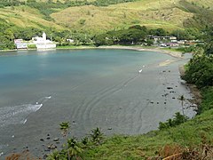
Umatac
 | |
| Państwo | |
|---|---|
| Terytorium nieinkorporowane | |
| Powierzchnia | 16 km² |
| Populacja (2010) • liczba ludności |
|
| Portal | |
Umatac (czamorro: Humåtak) – okręg administracyjny Guamu i jednocześnie jedna z miejscowości[1]. Okręg ma powierzchnię 16 km²[2], a zamieszkany jest przez 782 osób (dane spisowe z 2010)[3].
Przypisy
- ↑ Topografic map of Guam, Mariana Islands. 1:50.000. Denver: United States Department of the Interior Geological Survey, 1978.
- ↑ Municipalities of Guam. Administrative Divisions of Countries ("Statoids"). [dostęp 2014-04-09].
- ↑ Guam Statistical Yearbook 2010. Bureau of Statistics and Plans, Government of Guam. [dostęp 2014-04-09].
Media użyte na tej stronie
The flag of Navassa Island is simply the United States flag. It does not have a "local" flag or "unofficial" flag; it is an uninhabited island. The version with a profile view was based on Flags of the World and as a fictional design has no status warranting a place on any Wiki. It was made up by a random person with no connection to the island, it has never flown on the island, and it has never received any sort of recognition or validation by any authority. The person quoted on that page has no authority to bestow a flag, "unofficial" or otherwise, on the island.
The flag of Guam, courtesy an e-mail from the author of xrmap. Modifications by Denelson83.
Autor: Alexrk2, Licencja: CC BY-SA 3.0
Ta mapa została stworzona za pomocą GeoTools.
Autor: Uwe Dedering, Licencja: CC BY-SA 3.0
Location map of Oceania.
- Projection: Lambert azimuthal equal-area projection.
- Area of interest:
- N: 35.0° N
- S: -55.0° N
- W: 110.0° E
- E: 230.0° E (This is -130° E)
- Projection center:
- NS: -10.0° N
- WE: 170.0° E
- GMT projection: -JA170/-5/20c
- GMT region: -R79.58168799459713/-44.42200097096855/-120.83787447194456/33.90289238708686r
- GMT region for grdcut: -R80.0/-63.0/260.0/39.0r
- Made with Natural Earth. Free vector and raster map data @ naturalearthdata.com.


