Unimak
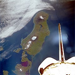
 Zdjęcie wyspy Unimak wykonane z pokładu wahadłowca Endeavour we wrześniu 1992 | |
| Państwo | |
|---|---|
| Stan | |
| Akwen | |
| Archipelag | |
| Powierzchnia | 4118 km² |
| Najwyższy punkt | 2857 m n.p.m. |
| 54°46′06″N 164°11′12″W/54,768333 -164,186667 | |
Unimak – największa i położona najbardziej na wschód wyspa Aleutów, wchodząca w skład Wysp Lisich. Wyspa mierzy 113 km długości oraz ok. 30–40 km szerokości. Zajmuje powierzchnię 4118 km²[1]. W 2000 wyspę zamieszkiwały 64 osoby, wszystkie w jedynej miejscowości na wyspie – False Pass.
Na wyspie Unimak znajduje się wulkan Mount Shishaldin, jeden z najbardziej aktywnych wulkanów na świecie. Wznosi się on na 2857 m n.p.m. i jest najwyższym szczytem Aleutów[2].
Ze względu na bliskie położenie w stosunku do stałego lądu półwyspu Alaska na wyspie znaleźć można wiele dużych ssaków, m.in. niedźwiedzia brunatnego czy karibu. Na wyspach położonych bardziej na zachód największym ssakiem jest lis rudy.
Zobacz też
Przypisy
- ↑ Unimak - oceandots.com (ang.). [dostęp 2010-12-23]. [zarchiwizowane z tego adresu (2010-12-23)].
- ↑ Shishaldin. [w:] Global Volcanism Program [on-line]. Smithsonian Institution. [dostęp 2020-01-12]. (ang.).
Media użyte na tej stronie
The flag of Navassa Island is simply the United States flag. It does not have a "local" flag or "unofficial" flag; it is an uninhabited island. The version with a profile view was based on Flags of the World and as a fictional design has no status warranting a place on any Wiki. It was made up by a random person with no connection to the island, it has never flown on the island, and it has never received any sort of recognition or validation by any authority. The person quoted on that page has no authority to bestow a flag, "unofficial" or otherwise, on the island.
Autor: Uwe Dedering, Licencja: CC BY-SA 3.0
Relief location map of North America.
- Projection: Lambert azimuthal equal-area projection.
- Area of interest:
- N: 90.0° N
- S: 5.0° N
- W: -140.0° E
- E: -60.0° E
- Projection center:
- NS: 47.5° N
- WE: -100.0° E
- GMT projection: -JA-100/47.5/20.0c
- GMT region: -R-138.3726888474925/-3.941007863604182/2.441656573833029/50.63933645705661r
- GMT region for grdcut: -R-220.0/-4.0/20.0/90.0r
- Relief: SRTM30plus.
- Made with Natural Earth. Free vector and raster map data @ naturalearthdata.com.
Unimak Island, Alaska, United States - September 1992
Seen in this southwest-looking, low-oblique photograph is Unimak Island, Alaska, the largest island in the Aleutian chain. The major volcano on the island (snow-capped peak at the center of the photograph), Shishaldin, rises approximately 9400 feet (2860 meters) and has been active during the last 175 years, with several eruptions occurring recently. The volcano is known locally as "Smoking Moses." At the southwestern end of the island is the snow-capped Pogromni Volcano. The blue lake situated in a large volcanic caldera, which can be seen midway between the Pogromni and Shishaldin volcanoes, is the result of a now extinct volcano that collapsed.
Shishaldin Volcano on the west end of Unimak Island.
   Image ID: line6680, NOAA's America's Coastlines Collection
   Location: Alaska, Shishaldin Volcano
Credit: Crew and Officers of NOAA Ship FAIRWEATHER
Autor: Wikisoft* @@@-fr 07:08, 27 April 2011 (UTC), Licencja: GFDL
Carte Alaska Relief R3 jpg (Changement des couleurs)


