Union Station (Los Angeles)
 | |
| Państwo | |
|---|---|
| Miejscowość | |
| Data otwarcia | 1939 |
| Liczba pasażerów (2011) | 1 606 121 |
| Dane techniczne | |
| Liczba peronów | 5 |
| Liczba krawędzi peronowych | 10 |
| Kasy | czynne |
| Linie kolejowe | |
| |
Schemat linii kolejowych, metra, szybkiego tramwaju i bus rapid transit w Hrabstwie Los Angeles | |
| 34°03′22″N 118°14′03″W/34,056111 -118,234167 | |
| Strona internetowa | |
| Portal | |
 Stacja metra Union Station widok z górnego poziomu (2015) | |
| Państwo | |
|---|---|
| Data otwarcia | Górny poziom: 26 lipca 2003 |
| Liczba peronów | Górny poziom: 1 |
| Liczba krawędzi peronowych | Górny poziom: 2 |
| Poprzednia stacja | stacja końcowa (linia B i linia D oraz linia J) |
| Następna stacja | Civic Center/Grand Park (linia B i linia D oraz linia J) |
Położenie na mapie metropolii Los Angeles  | |
Położenie na mapie Stanów Zjednoczonych  | |
Położenie na mapie Kalifornii  | |
| Portal | |
Los Angeles Union Station – największa i główna stacja kolejowa w Los Angeles. Jest jednym z największych dworców kolejowych w USA. W 2010 obsłużył 1 517 342 pasażerów[1].
Los Angeles Union Station obsługuje pociągi operatorów Amtrak i Metrolink. Jest także ważnym punktem przesiadkowym. Znajduje się tutaj peron podziemnej stacji metra obsługującej linię B, D linię metra w Los Angeles, naziemnej stacji metra linii L, dworzec autobusowy oraz przystanek linii J w systemie Los Angeles Metro Busway[2]. Przed stacją znajduje się pętla autobusowa. Obiekt otwarto w maju 1939 roku. Uchodzi za ostatnią z „wielkich stacji kolejowych” w USA.
Galeria

Widok z ulicy

Poczekalnia

Przykładowa mozaika stanowiąca element wystroju stacji

Ozdobna lampa

Przystanek autobusowy linii J (2020)
Tramwaj obsługujący ówczesną złotą linię metra (obecną linię L) na stacji Union Station (2005)
Pociąg złożony z wagonów typu Breda A650 obsługujących czerwoną linię metra (współczesną linię B) na stacji Union Station (2008)

Pociąg Metrolinku na peronie
Znak stacji

Zobacz też
Przypisy
- ↑ Amtrak Fact Sheet, FY2010, State of California. Amtrak, November 2010. [dostęp 2011-06-13].
- ↑ Maps & Schedules - LA Metro. [dostęp 2022-07-24]. (ang.).
Linki zewnętrzne
| Stacje istniejące | |
|---|---|
| Stacje planowane |
|


| Usługi Metro |
| ||||||
|---|---|---|---|---|---|---|---|
| Wyposażenie i stacje |
| ||||||
| Główne projekty |
| ||||||
| Inne informacje |
|

| Dzielnice i osiedla | |
|---|---|
| Ciekawe miejsca |
|
_edit1.jpg)
- Downtown
- Northeast/Eastside
- Harbor Area
- Greater Hollywood
- Westlake/Silver Lake/Los Feliz
- San Fernando Valley
- South Los Angeles
- Westside
- Wilshire
- Portal:Wielkie Los Angeles
- Wikiprojekt:Kalifornia
Media użyte na tej stronie
Autor: Uwe Dedering, Licencja: CC BY-SA 3.0
Location map of the USA (without Hawaii and Alaska).
EquiDistantConicProjection:
Central parallel:
* N: 37.0° N
Central meridian:
* E: 96.0° W
Standard parallels:
* 1: 32.0° N
* 2: 42.0° N
Made with Natural Earth. Free vector and raster map data @ naturalearthdata.com.
Formulas for x and y:
x = 50.0 + 124.03149777329222 * ((1.9694462586094064-({{{2}}}* pi / 180))
      * sin(0.6010514667026994 * ({{{3}}} + 96) * pi / 180))
y = 50.0 + 1.6155950752393982 * 124.03149777329222 * 0.02613325650382181
      - 1.6155950752393982  * 124.03149777329222 *
     (1.3236744353715044  - (1.9694462586094064-({{{2}}}* pi / 180))
      * cos(0.6010514667026994 * ({{{3}}} + 96) * pi / 180))
Autor: NordNordWest, Licencja: CC BY 3.0
Location map of California, USA

The flag of Navassa Island is simply the United States flag. It does not have a "local" flag or "unofficial" flag; it is an uninhabited island. The version with a profile view was based on Flags of the World and as a fictional design has no status warranting a place on any Wiki. It was made up by a random person with no connection to the island, it has never flown on the island, and it has never received any sort of recognition or validation by any authority. The person quoted on that page has no authority to bestow a flag, "unofficial" or otherwise, on the island.

A specific Metro line identifier.
Autor: Alexrk2, Licencja: CC BY 3.0
Ta mapa została stworzona za pomocą GeoTools.

The icon for the Metro A line.

Red Line circle.

A specific Metro line identifier.
Autor: Salaam Allah (http://en.wikipedia.org/wiki/User:Labanex), Licencja: CC BY 2.5
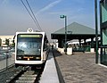
Metro Gold Line trains at Memorial Park Station in Pasadena, California from English Wikipedia.

(c) The Port of Authority z angielskiej Wikipedii, CC BY-SA 3.0
Breda A650 subway car trainset on the Los Angeles Metro Rail Red Line at Union Station.

Silver Line square (for Los Angeles Metro).

Autor: Oryginalnym przesyłającym był DaveofCali z angielskiej Wikipedii, Licencja: CC BY 2.0
Gold Line train platform at Union Station
Photo taken by user DaveofCali (David Liu)
Autor: Mackerm z angielskiej Wikipedii, Licencja: CC-BY-SA-3.0
Waiting room of Union Station, Los Angeles. (Train station).
Autor: Brion VIBBER, Licencja: CC-BY-SA-3.0
West facade of the Los Angeles City Hall — in Downtown Los Angeles, California.
- In process of seismic upgrading, this 1928 high-rise building was placed atop a mechanical system of isolators, sliders, and dampers called "base isolation technology".
- It is the tallest base-isolated structure in the world.

Purple Line circle.

Gold Line circle.

(c) Gatoona z angielskiej Wikipedii, CC BY 3.0
A view of the Union Station sign, familiar to many of downtown Los Angeles' visitors.
(c) The Port of Authority & Cian Ginty, CC BY-SA 3.0
An example of the different types of services Metro provides. From top-left clockwise: light rail, bus, bus rapid transit, and rapid transit (subway).

Autor: Elinruby, Licencja: CC BY-SA 3.0
lobby of Union Station in Los Angeles

Orange Line square (for Los Angeles Metro).

Metro B line icon.
Autor: jjron, Licencja: GFDL 1.2
Los Angeles Union Station, main entrance on Alameda St. Los Angeles, California, USA.
The newly-completed El Monte Busway platform at Patsaouras Transit Plaza in November 2020

A specific Metro line identifier.

Metrolink MP36PH-3C locomotive #888 at Los Angeles Union Station
Autor: HanSangYoon, Licencja: CC BY-SA 4.0
The upper floor view of Union Station Station.

Autor: Oryginalnym przesyłającym był Jepler z angielskiej Wikipedii, Licencja: CC BY-SA 2.5
A picture of an ornate Art Deco lamp that hangs from the rafters of the waiting room in the Los Angeles Union Train Station. The picture was taken by Jim Epler in 2006. A higher resolution version of this photograph can be found at http://edtech.guhsd.net/gallery/details.php?iid=177.
Autor: Pacific Coast Highway, Licencja: CC BY 3.0
A map of the Los Angeles County Metro Rail (light rail rapid transit ) and Metro Liner (bus rapid transit ) systems — in Los Angeles County, Southern California. (PDF version)

Autor: The Angels 2010, Licencja: CC BY-SA 3.0
Union Station, Los Angeles