University of Leicester
 | |
| Dewiza | Ut Vitam Habeant |
|---|---|
| Data założenia | 1921 |
| Typ | publiczna |
| Państwo | |
| Adres | University Road, Leicester LE1 7RH |
| Rektor | Lord Grocott |
Położenie na mapie Leicesteru .svg "Mapa lokalizacyjna Leicesteru") Contains Ordnance Survey data © Crown copyright and database right, CC BY-SA 3.0 | |
Położenie na mapie Wielkiej Brytanii  (c) Karte: NordNordWest, Lizenz: Creative Commons by-sa-3.0 de | |
Położenie na mapie Anglii  | |
Położenie na mapie Leicestershire  Contains Ordnance Survey data © Crown copyright and database right, CC BY-SA 3.0 | |
| Strona internetowa | |
University of Leicester – publiczny uniwersytet w mieście Leicester w Wielkiej Brytanii, prowadzący studia licencjackie, magisterskie i doktoranckie.
Uczelnia została założona w 1921 roku, status uniwersytetu uzyskała w 1957. Plasowała się na 15. miejscu rankingu według Times Higher Education z 2008 roku. Wśród brytyjskich uczelni zajęła 9. miejsce według Thomson Scientific.
Na uniwersytecie prowadzone są badania naukowe na światowym poziomie[1], między innymi odkryto na nim DNA.
Uczelnia oferuje wiele kierunków kształcenia, w tym[2]:
- nauki biologiczne
- zarządzanie
- komunikacja, media
- informatyka
- ekonomia
- inżynieria ogólna
- edukacja
- elektronika, elektrotechnika
- matematyka
- fizyka
- inżynieria mechaniczna
- finanse, księgowość
- nauki przyrodnicze
- geografia
- historia
- archeologia
- nauki humanistyczne
- stosunki międzynarodowe
- językoznawstwo
- prawo
- literatura
- politologia
- medycyna, farmacja
- psychologia, socjologia.

Engineering Building

Budynek uniwersytetu
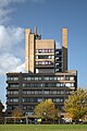
Widok na budynek uniwersytetu od strony Victoria Park

Uniwersytecki zegar astronomiczny
Przypisy
- ↑ Complete A-Z of University of Leicester — University of Leicester, www2.le.ac.uk [dostęp 2017-11-20] (ang.).
- ↑ Zarchiwizowana kopia. [dostęp 2014-03-08]. [zarchiwizowane z tego adresu (2014-03-09)].
Linki zewnętrzne
- Oficjalna strona uczelni (ang.)
Media użyte na tej stronie
(c) Karte: NordNordWest, Lizenz: Creative Commons by-sa-3.0 de
Location map of the United Kingdom


Autor: NotFromUtrecht, Licencja: CC BY-SA 3.0
University of Leicester, UK.

Autor: Alun Salt from Derby and Leicester, UK, Licencja: CC BY-SA 2.0
Astronomical Clock at Leicester University

Autor: NotFromUtrecht, Licencja: CC BY-SA 3.0
View north from the Charles Wilson Building at the University of Leicester. The Physics and Astronomy building seen here was designed by Leslie Martin[1]

Autor: NotFromUtrecht, Licencja: CC BY-SA 3.0
The Engineering Building, University of Leicester, designed by James Stirling and Grade II* star listed
Contains Ordnance Survey data © Crown copyright and database right, CC BY-SA 3.0
Map of Leicester, Leicestershire, UK with electoral wards shown.
Equirectangular map projection on WGS 84 datum, with N/S stretched 160%
Geographic limits:
- West: 1.22W
- East: 1.04W
- North: 52.70N
- South: 52.57N
Contains Ordnance Survey data © Crown copyright and database right, CC BY-SA 3.0
Map of Leicestershire, UK with the following information shown:
- Administrative borders
- Coastline, lakes and rivers
- Roads and railways
- Urban areas
Equirectangular map projection on WGS 84 datum, with N/S stretched 160%
Geographic limits:
- West: 1.80W
- East: 0.50W
- North: 53.00N
- South: 52.36N

Autor: NotFromUtrecht, Licencja: CC BY-SA 3.0
The Charles Wilson Building (designed by Denys Lasdun) at the University of Leicester, seen from Victoria Park