Uniwersytet Pittsburski
 | |
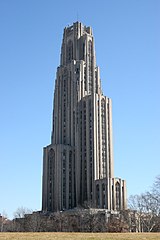
 Katedra Nauki Uniwersytetu Pittsburskiego (drugi pod względem wysokości budynek edukacyjny na świecie) | |
| Dewiza | Veritas et Virtus |
|---|---|
| Data założenia | 1787 |
| Typ | |
| Państwo | |
| Liczba pracowników • naukowych |
|
| Liczba studentów | 28 617 |
| Strona internetowa | |
Uniwersytet Pittsburski[1][2] (ang. University of Pittsburgh) – uniwersytet w mieście Pittsburgh, w Stanach Zjednoczonych, założony w 1787 roku.
W 2013 był na 19. miejscu w rankingu amerykańskich uniwersytetów publicznych[3] i 57. w rankingu wszystkich amerykańskich uniwersytetów. Znany jest zwłaszcza ze swojej szkoły medycznej i ekonomicznej.
Jego Katedra Nauki (Cathedral of Learning), mająca około 163 m wysokości, jest drugim co do wysokości budynkiem edukacyjnym na świecie[4].
Zobacz też
Przypisy
- ↑ Uniwersytet Pittsburski wprowadza naukę języka polskiego. University of Pittsburgh, 2010-03-11. [dostęp 2013-09-04].
- ↑ Jan Grzenia: O problemach z polonizacją nazw uniwersytetów amerykańskich. 2001. [dostęp 2018-11-02].
- ↑ College Rankings & Lists (ang.). [dostęp 2013-09-04].
- ↑ Cathedral of Learning (ang.). [dostęp 2013-09-04].
Linki zewnętrzne
Media użyte na tej stronie
Autor: Uwe Dedering, Licencja: CC BY-SA 3.0
Location map of the USA (without Hawaii and Alaska).
EquiDistantConicProjection:
Central parallel:
* N: 37.0° N
Central meridian:
* E: 96.0° W
Standard parallels:
* 1: 32.0° N
* 2: 42.0° N
Made with Natural Earth. Free vector and raster map data @ naturalearthdata.com.
Formulas for x and y:
x = 50.0 + 124.03149777329222 * ((1.9694462586094064-({{{2}}}* pi / 180))
      * sin(0.6010514667026994 * ({{{3}}} + 96) * pi / 180))
y = 50.0 + 1.6155950752393982 * 124.03149777329222 * 0.02613325650382181
      - 1.6155950752393982  * 124.03149777329222 *
     (1.3236744353715044  - (1.9694462586094064-({{{2}}}* pi / 180))
      * cos(0.6010514667026994 * ({{{3}}} + 96) * pi / 180))
The flag of Navassa Island is simply the United States flag. It does not have a "local" flag or "unofficial" flag; it is an uninhabited island. The version with a profile view was based on Flags of the World and as a fictional design has no status warranting a place on any Wiki. It was made up by a random person with no connection to the island, it has never flown on the island, and it has never received any sort of recognition or validation by any authority. The person quoted on that page has no authority to bestow a flag, "unofficial" or otherwise, on the island.
Autor: unknown, Licencja:
A map of the city of Pittsburgh and its surrounding areas
Cathedral of Learning at the University of Pittsburgh,
Photo Credit: https://www.flickr.com/photos/pjah73/410669224/Autor: Alexrk2, Licencja: CC BY 3.0
Location map of Pennsylvania, USA


