Uniwersytet Południowej Kalifornii
 | |
| Dewiza | Palmam qui meruit ferat |
|---|---|
| Data założenia | 1880 |
| Typ | świecki uniwersytet prywatny |
| Państwo | |
| Stan | |
| Adres | Los Angeles |
| Liczba pracowników • naukowych | 10 774 |
| Liczba studentów | 34 824 |
| Członkostwo | |
| Drużyna sportowa | |
Położenie na mapie metropolii Los Angeles  | |
Położenie na mapie Stanów Zjednoczonych  | |
Położenie na mapie Kalifornii  | |
| Strona internetowa | |
Uniwersytet Południowej Kalifornii (ang. University of Southern California, USC) – uczelnia o statusie świeckiego uniwersytetu prywatnego, z siedzibą w Los Angeles w stanie Kalifornia, która powstała w 1880 roku. Obecnie USC kształci około 35 tysięcy studentów, w tym 17 tysięcy słuchaczy studiów licencjackich oraz 18 tysięcy magistrantów i doktorantów. Uczelnia zatrudnia około 11 tysięcy osób, w tym 4700 pracowników naukowych[1]. Należy do najbardziej prestiżowych uniwersytetów amerykańskich.
Uniwersytet należy do Pacific-10 Conference. Jego drużyny sportowe występują jako USC Trojans. Uczelnia dysponuje halą sportową na ponad 10 tysięcy widzów (Galen Center). Jej zespół futbolu amerykańskiego rozgrywa swoje mecze na Los Angeles Memorial Coliseum (stadionie olimpijskim z lat 1932 i 1984). Jak dotąd 362 jej studentów i absolwentów wzięło udział w igrzyskach olimpijskich, zdobywając 112 złotych, 66 srebrnych i 58 brązowych medali[2].
Znani absolwenci
- Neil Armstrong – astronauta, pierwszy człowiek na Księżycu
- Miranda Cosgrove – aktorka, piosenkarka
- Warren Christopher – polityk, sekretarz stanu USA w administracji Billa Clintona
- Chris DeWolfe – współtwórca portalu MySpace.com
- Will Ferrell – aktor i komik
- Frank Gehry – architekt
- Jerry Goldsmith – kompozytor
- Dexter Holland – muzyk zespołu The Offspring
- Marilyn Horne – śpiewaczka operowa
- James Horner – kompozytor
- George Lucas – reżyser i producent filmowy, twórca Gwiezdnych Wojen
- O.J. Mayo – koszykarz
- Pat Nixon – była pierwsza dama USA
- John Ritter – aktor i komik
- Gene Roddenberry – scenarzysta i producent filmowy i telewizyjny, twórca Star Trek
- Norman Schwarzkopf – wojskowy, dowódca operacji „Pustynna Burza”
- O.J. Simpson – futbolista i aktor
- Forest Whitaker – aktor i reżyser
- Scott Hoying - muzyk, influencer, współtwórca Pentatonix
Galeria
 (c) Padsquad19, CC-BY-SA-3.0
Biblioteka Doheny’ego
 (c) Padsquad19, CC-BY-SA-3.0
Zumberge Hall
Gmach Centrum Medycznego
 (c) Padsquad19, CC-BY-SA-3.0
Gmach samorządu studenckiego

Budynek Absolwentów

Teatr uniwersytecki
Nowy szpital uniwersytecki

Przypisy
- ↑ Dane uczelni z 2010 roku. usc.edu. [zarchiwizowane z tego adresu (2010-05-24)]..
- ↑ About USC, 2008/2009.
Linki zewnętrzne
| Dzielnice i osiedla |
|
|---|---|
| Ciekawe miejsca |
|
| Zobacz też |
|

- Downtown
- Northeast/Eastside
- Harbor Area
- Greater Hollywood
- Westlake/Silver Lake/Los Feliz
- San Fernando Valley
- South Los Angeles
- Westside
- Wilshire
- Portal:Wielkie Los Angeles
- Wikiprojekt:Kalifornia
Media użyte na tej stronie
Autor: Uwe Dedering, Licencja: CC BY-SA 3.0
Location map of the USA (without Hawaii and Alaska).
EquiDistantConicProjection:
Central parallel:
* N: 37.0° N
Central meridian:
* E: 96.0° W
Standard parallels:
* 1: 32.0° N
* 2: 42.0° N
Made with Natural Earth. Free vector and raster map data @ naturalearthdata.com.
Formulas for x and y:
x = 50.0 + 124.03149777329222 * ((1.9694462586094064-({{{2}}}* pi / 180))
      * sin(0.6010514667026994 * ({{{3}}} + 96) * pi / 180))
y = 50.0 + 1.6155950752393982 * 124.03149777329222 * 0.02613325650382181
      - 1.6155950752393982  * 124.03149777329222 *
     (1.3236744353715044  - (1.9694462586094064-({{{2}}}* pi / 180))
      * cos(0.6010514667026994 * ({{{3}}} + 96) * pi / 180))
Autor: NordNordWest, Licencja: CC BY 3.0
Location map of California, USA

The flag of Navassa Island is simply the United States flag. It does not have a "local" flag or "unofficial" flag; it is an uninhabited island. The version with a profile view was based on Flags of the World and as a fictional design has no status warranting a place on any Wiki. It was made up by a random person with no connection to the island, it has never flown on the island, and it has never received any sort of recognition or validation by any authority. The person quoted on that page has no authority to bestow a flag, "unofficial" or otherwise, on the island.

Flag of California. This version is designed to accurately depict the standard print of the bear as well as adhere to the official flag code regarding the size, position and proportion of the bear, the colors of the flag, and the position and size of the star.

Autor: Alexrk2, Licencja: CC BY 3.0
Ta mapa została stworzona za pomocą GeoTools.

Autor: Bobak Ha'Eri, Licencja: CC BY 3.0
Fountain and the Bovard Administration Building at the University of Southern California in Los Angeles, California
Watts Towers


(c) Padsquad19, CC-BY-SA-3.0
Photo taken by Padsquad. Please observe license and properly cite in use outside Wikipedia.

(c) Padsquad19, CC-BY-SA-3.0
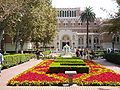
Doheny Library and gardens with fountain — at the University of Southern California.
- 1932 library in the Romanesque Revival style, by Ralph Adams Cram.
- Photo taken by Padsquad. Please observe license and properly cite in use outside Wikipedia.

Autor: Oryginalnym przesyłającym był Bobak z angielskiej Wikipedii, Licencja: CC BY-SA 2.5
Widney Alumni House, the original structure of the en:University of Southern California. Build in 1880, it has been moved twice, its original location was in the middle of what is now Founder's Park. It is the oldest university structure in Southern California.
This photo was taken during en:Homecoming, thus the extra banner over the door.
Photo taken by Bobak Ha'Eri, on November 11, 2006. Please observe license and properly cite in use outside Wikipedia.
en:Category:Images of Los Angeles, California
Autor: Downtowngal, Licencja: CC BY-SA 3.0
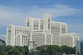
Front of the clinic tower of the new hospital building of the Los Angeles County/University of Southern California (LAC+USC) Medical Center, in Los Angeles, California, opened November 2008.
USC Seal

(c) Padsquad19, CC-BY-SA-3.0
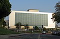
The Zumberge Hall of Science on the USC-University of Southern California campus building.
- Housing the Southern California Earthquake Center.
- The 1928 Romanesque Revival style building was designed by John and Donald Parkinson.
- Credits

(c) Bestweekevr at en.wikipedia, CC BY 2.5
I took this picture myself of the LAC+USC Medical Center. Please observe license and properly cite in use outside Wikipedia.