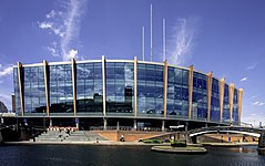
Utilita Arena Birmingham
 | |
| Państwo | |
|---|---|
| Kraj | |
| Miejscowość | |
| Adres | King Edwards Road |
| Lata budowy | 1989–1991 |
| Otwarta | 4 października 1991 |
| Architekt | Broadway Malyan |
| Właściciel | National Exhibition Centre |
| Operator | National Exhibition Centre |
| Liczba miejsc | |
| Stałych | 15 800[1] |
| Siedzących (w sumie) | 15 800 |
| Całkowita | 15 800 |
Położenie na mapie Birmingham Contains Ordnance Survey data © Crown copyright and database right, CC BY-SA 3.0 | |
Położenie na mapie Wielkiej Brytanii (c) Karte: NordNordWest, Lizenz: Creative Commons by-sa-3.0 de | |
Położenie na mapie West Midlands Contains Ordnance Survey data © Crown copyright and database right, CC BY-SA 3.0 | |
| Strona internetowa | |
Utilita Arena Birmingham (w latach 1991–2014 National Indoor Arena, w latach 2014–2017 Barclaycard Arena, w latach 2017–2020 Arena Birmingham[2]) – hala widowiskowo-sportowa w Birmingham, wybudowana w latach 1989–1991 i otwarta 4 października 1991[3], jako największy tego typu obiekt w Wielkiej Brytanii. Przebudowana w latach 2013–2014 kosztem 26 mln funtów. Posiada trybuny o pojemności 15 800 miejsc. Odbywają się w niej zarówno wydarzenia sportowe, jak i artystyczne.
Na przestrzeni lat w arenie miały miejsce m.in.: mistrzostwa świata w badmintonie, mecze tenisowe w ramach Pucharu Davisa, mistrzostwa świata w judo, WWE Raw i Smackdown, finał konkursu Eurowizji, a także koncerty takich artystów jak m.in.: Bob Dylan, Beyonce, Tina Turner, Britney Spears, Iron Maiden, Coldplay, Kings of Leon, Nickelback, Mariah Carey i Celine Dion.
W 2003 odbyły się tutaj halowe mistrzostwa świata w lekkoatletyce, cztery lata później halowe mistrzostwa Europy, natomiast w 2018 ponownie halowy czempionat globu.
Przypisy
- ↑ NIA Factsheet. thenia.co.uk. s. 2. [dostęp 2013-10-20]. [zarchiwizowane z tego adresu (2011-07-28)]. (ang.).
- ↑ Arena Birmingham to be renamed Utilita Arena Birmingham | Stadia Magazine, www.stadia-magazine.com [dostęp 2020-07-09] (ang.).
- ↑ Birmingham NIA. activbirmingham.com, 2010-07-15. [dostęp 2013-10-20]. [zarchiwizowane z tego adresu (2015-10-18)]. (ang.).
Linki zewnętrzne
- Oficjalna strona. thenia.co.uk. [zarchiwizowane z tego adresu (2008-12-02)]. (ang.)
- Konstrukcja dachu Areny. merouk.co.uk. [zarchiwizowane z tego adresu (2007-02-07)]. (ang.)
Media użyte na tej stronie
(c) Karte: NordNordWest, Lizenz: Creative Commons by-sa-3.0 de
Location map of the United Kingdom
Flag of England. Saint George's cross (a red cross on a white background), used as the Flag of England, the Italian city of Genoa and various other places.
Autor: Bs0u10e01, Licencja: CC BY-SA 4.0
The Barclaycard Arena, Birmingham in 2015
Contains Ordnance Survey data © Crown copyright and database right, CC BY-SA 3.0
Map of the West Midlands, UK with the following information shown:
- Administrative borders
- Coastline, lakes and rivers
- Roads and railways
- Urban areas
Equirectangular map projection on WGS 84 datum, with N/S stretched 160%
Geographic limits:
- West: 2.22W
- East: 1.40W
- North: 52.68N
- South: 52.33N
Contains Ordnance Survey data © Crown copyright and database right, CC BY-SA 3.0
Map of Birmingham, West Midlands, UK with electoral wards shown.
Equirectangular map projection on WGS 84 datum, with N/S stretched 160%
Geographic limits:
- West: 2.05W
- East: 1.72W
- North: 52.62N
- South: 52.37N


