Uttlesford
| dystrykt niemetropolitalny | |
 | |
| Państwo | |
|---|---|
| Kraj | |
| Region | East of England |
| Hrabstwo | Essex |
| Siedziba | Saffron Walden |
| Powierzchnia | 641,18 km² |
| Populacja (2011) • liczba ludności | 80 000 |
| • gęstość | 120 os./km² |
| Plan | |
 | |
| Położenie na mapie Essex Contains Ordnance Survey data © Crown copyright and database right, CC BY-SA 3.0 | |
| Strona internetowa | |
| Portal | |
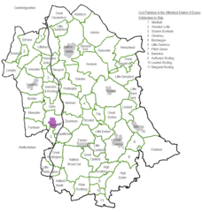
Uttlesford – dystrykt w hrabstwie Essex w Anglii.
Miasta
Inne miejscowości
Arkesden, Ashdon, Aythorpe Roding, Bannister Green, Barnston, Berden, Birchanger, Broxted, Chrishall, Clavering, Debden, Elmdon, Elsenham, Farnham, Felsted, Flitch Green, Great Canfield, Great Chesterford, Great Easton, Great Hallingbury, Great Sampford, Hadstock, Hatfield Broad Oak, Hatfield Heath, Henham, High Easter, Langley, Little Bardfield, Little Chesterford, Little Dunmow, Little Easton, Little Hallingbury, Little Walden, Littlebury, Manuden, Manwood Green, Newport, Quendon, Quendon and Rickling, Sewards End, Stansted Mountfitchet, Stebbing, Strethall, Takeley, Wendens Ambo, Wicken Bonhunt, Wimbish.
Media użyte na tej stronie
Flag of England. Saint George's cross (a red cross on a white background), used as the Flag of England, the Italian city of Genoa and various other places.
Autor: Adam37, Licencja: CC BY-SA 3.0
Map of Town Councils and Parish Councils for Civil Parishes in Uttlesford, Essex, United Kingdom.
Contains Ordnance Survey data © Crown copyright and database right, CC BY-SA 3.0
Map of Essex, UK with Uttlesford highlighted.
Equirectangular map projection on WGS 84 datum, with N/S stretched 160%


