Västerort
| ||||
| ||||
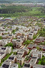
 Widok na Kista. W głębi Rinkeby | ||||
| Państwo | ||||
| Region | Sztokholm | |||
| Miasto | Sztokholm | |||
| Powierzchnia | 77,04 km² | |||
| Populacja (2014) • liczba ludności | 233 113 | |||
| • gęstość | 3386 os./km² | |||
Położenie na mapie Sztokholmu | ||||
| 59°21′23″N 17°54′46″E/59,356389 17,912778 | ||||
| Strona internetowa | ||||
| Portal | ||||
Västerort – jeden z trzech obszarów (stadsområde) gminy Sztokholm, położony na zachód i północny zachód od centrum miasta i zaliczany do Yttre staden (Ytterstaden).
Västerort obejmuje 44 dzielnice (stadsdel), zgrupowane od 1 stycznia 2007 r. w czterech okręgach administracyjnych (stadsdelsområde):
W 2014 r. Västerort liczył 233 118 mieszkańców. Jego powierzchnia wynosi 77,04 km², z czego wody stanowią 8,2 km²[1].
Przypisy
- ↑ Stockholms stad: Areal och befolkningstäthet i stadsdelsområden, SDN-delar och stadsdelar 2014-12-31. Stockholm (szw.). [dostęp 2015-11-15].
Linki zewnętrzne
Media użyte na tej stronie
Autor: Koyos, Licencja: CC BY-SA 2.5
This coat of arms was drawn based on its blazon which – being a written description – is free from copyright. Any illustration conforming with the blazon of the arms is considered to be heraldically correct. Thus several different artistic interpretations of the same coat of arms can exist. The design officially used by the armiger is likely protected by copyright, in which case it cannot be used here.
Individual representations of a coat of arms, drawn from a blazon, may have a copyright belonging to the artist, but are not necessarily derivative works.
Autor: Ztaffanb, Licencja: CC-BY-SA-3.0
Kista (Borough of Rinkeby-Kista) in northern Stockholm, Sweden, seen from Kista Science tower
Autor: Alex Nordstrom, Jniemenmaa, Licencja: CC BY-SA 2.5
The boroughs (stadsdelsområden) of the municipality of Stockholm, Sweden as of 2007.


