Vaalserberg
| ||
 Widok od strony Niemiec | ||
| Państwo | ||
| Położenie | Vaals, Plombières, Kelmis, Akwizgran | |
| Pasmo | Ardeny | |
| Wysokość | 322,4 m n.p.m. | |
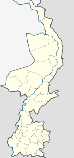
Położenie na mapie Holandii (c) Karte: NordNordWest, Lizenz: Creative Commons by-sa-3.0 de | ||
Vaalserberg – najwyższy punkt Holandii, położony w odległości około 20 metrów od trójstyku granic Holandii, Belgii i Niemiec. W latach 1830-1919 spotykały się w tym miejscu granice czterech państw – oprócz trzech dzisiejszych istniało wówczas terytorium sporne Moresnet, występowało tu zatem bardzo rzadkie w geografii politycznej zjawisko czwórstyku. Obecnie Vaalserberg jest atrakcją turystyczną. Znajdują się na nim dwie wieże widokowe, restauracje oraz labirynt. Vaalserberg należy do Korony Europy.
Linki zewnętrzne
Media użyte na tej stronie
Autor: Erik Frohne, Licencja: CC BY-SA 3.0
Location map of province Limburg in the Netherlands
Equirectangular projection, N/S stretching 160 %. Geographic limits of the map:
- N: 51.782° N
- S: 50.744° N
- W: 5.56° E
- E: 6.34° E
Black up-pointing triangle ▲, U+25B2 from Unicode-Block Geometric Shapes (25A0–25FF)
Autor: Ahoerstemeier, Licencja: CC-BY-SA-3.0
The Drielandenpunt (Three country point, Dreiländereck), the point where the boundaries of Germany, the Netherlands and Belgium converge, near the city of Aachen (Germany) and Vaals (Netherlands). Photo taken in 2000 (?) by User:Ahoerstemeier
Drielandenpunt, with in the right the "Labyrinth Drielandenpunt". Picture from the Boudenwijntoren.
(c) Karte: NordNordWest, Lizenz: Creative Commons by-sa-3.0 de
Location map of the Netherlands


