Valle Aurelia
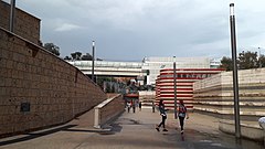
(c) Sergio D’Afflitto, CC BY-SA 4.0 | |
| Państwo | |
|---|---|
| Data otwarcia | 29 maja 1999 |
| Poprzednia stacja | |
| Następna stacja | |
| Portal | |
Valle Aurelia – stacja na linii A metra rzymskiego. Stacja została otwarta w 1999. Poprzednim przystankiem jest Baldo degli Ubaldi, a następnym Cipro.
Media użyte na tej stronie
Autor: Dr. Blofeld, insert originally by Nordnordwest, Licencja: CC BY-SA 2.0
Map of Rome. Italy
Geographic limits of the map:
- N: 41.993°
- S: 41.792°
- W: 12.308°
- E: 12.685°
Autor: NordNordWest, Licencja: CC BY-SA 3.0
Location map of Italy (Commons photos) → en-Wikipedia Italy.
Autor:
- Map_of_region_of_Lazio,_Italy.svg: User:Vonvikken
- derivative work: Milenioscuro (talk)
Location map of Lazio region (Italy)
Icon of Rome underground line A.
Icon of Rome underground line A.
Icon of Rome underground line B.
Icon of Rome underground line B.
Icon of Rome underground line C.
Icon of Rome underground line C.
Icon of Rome underground line B, branch B1.
Icon of Rome underground line B, branch B1.
Logo delle metropolitane in Italia
(c) Sergio D’Afflitto, CC BY-SA 4.0
The ground level of the interchange station of Valle Aurelia in Rome, Italy. At the top there's the station on the railway line Viterbo-Rome operated by Ferrovie Italiane; beneath there's the metro station operated by ATAC, Rome's public transport company. Both stations have the same name.


