Vannes
| gmina | |||||
 | |||||
| Państwo | |||||
|---|---|---|---|---|---|
| Region | |||||
| Departament | |||||
| Okręg | |||||
| Kod INSEE | 56260 | ||||
| Mer | David Robo | ||||
| Powierzchnia | 32,3 km² | ||||
| Populacja (1990) • liczba ludności |
| ||||
| • gęstość | 1413 os./km² | ||||
| Kod pocztowy | 56000 | ||||
Położenie na mapie Morbihan  | |||||
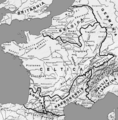
Położenie na mapie Francji  | |||||
Położenie na mapie Bretanii  | |||||
| Portal | |||||
Vannes (bret. Gwened) – miejscowość i gmina we Francji, w regionie Bretania, w departamencie Morbihan. Stolica celtycka Wenetów. W II w. miasto otrzymało obecną nazwę. Od V w. było siedzibą biskupa. Po zwycięstwie Pepina Krótkiego nad Bretończykami w 753 roku znalazło się pod panowaniem Franków, w końcu w X w. zostało włączone do Bretanii i wraz z nią – w 1532 – do korony francuskiej.
Największym zabytkiem jest monumentalna, gotycko-romańska katedra pw. św. Piotra (wieża katedralna stanowi pozostałość romańskiej świątyni, znajdującej się uprzednio w tym miejscu).
Według danych na rok 1990 gminę zamieszkiwały 45 644 osoby, a gęstość zaludnienia wynosiła 1413 osób/km² (wśród 1269 gmin Bretanii, Vannes plasuje się na 6. miejscu pod względem liczby ludności, natomiast pod względem powierzchni na miejscu 236.).
Znane osoby urodzone w Vannes
- Albin z Angers (zm. 549), święty Kościoła katolickiego
- Jan VI Mądry, książę Bretanii 1399–1442
- Franciszek I Bretoński, książę Bretanii 1442–1450
- Artur III Bretoński, książę Bretanii 1457–1458
- Alain Resnais (1922–2014), reżyser filmowy należący do tzw. francuskiej nowej fali
- Louise Bourgoin (ur. 1981), aktorka, modelka
Miasta partnerskie
Bibliografia
- Francuski urząd statystyczny. (fr.).

Herb

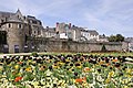
Starówka
Mury miejskie
Mapa Galii z lokalizacją Wenetów
Media użyte na tej stronie
Autor: Eric Gaba (Sting - fr:Sting), Licencja: CC BY-SA 3.0
Blank administrative map of the department of Morbihan, France, for geo-location purpose, with distinct boundaries for regions, departments and arrondissements.
Autor: Superbenjamin, Licencja: CC BY-SA 4.0
Blank administrative map of France for geo-location purpose, with regions and departements distinguished. Approximate scale : 1:3,000,000
Autor: Eric Gaba (Sting - fr:Sting), Licencja: CC BY-SA 3.0
Blank administrative map of the region of Bretagne, France, for geo-location purpose, with distinct boundaries for regions, departments and arrondissements.
.svg)
.svg)


Autor: Lexicon and GwenofGwened, Licencja: CC BY-SA 4.0
Traditional flag of Brittany

Autor: Andreas G. Törl, Licencja: CC BY-SA 2.5
Old town of Vannes (Bretagne, France)

(c) Photo: Myrabella / Wikimedia Commons, CC BY-SA 3.0
City walls of Vannes, Morbihan, France, from tour Poudrière (= "Powder magazine Tower") to tour Joliette (="Joliette Tower"), during the "Photo de mer" festival in spring 2010.

Autor: This image has been made by GwenofGwened and released under the licenses stated below. You are free to use it for any purpose as long as you credit me as author, Wikimedia Commons as site and follow the terms of the licenses. Could you be kind enough to leave me a message on this page to inform me about your use of this picture., Licencja: CC BY-SA 4.0
Drapeau de la Ville de Vannes en SVG

Autor: User:Feitscherg, Licencja: CC-BY-SA-3.0
Roman provinces and the proto-Basque, Celtic and Germanic peoples at the end of the 1st century BC. J-C.


Autor: Mathieu CHAINE, Licencja: CC BY-SA 3.0
Grandes armes de la ville de Vannes (56)
(c) Photo: Myrabella / Wikimedia Commons, CC BY-SA 3.0
The port of Vannes, Morbihan, France: quay Éric Tabarly, at the foot of St. Vincent gate.