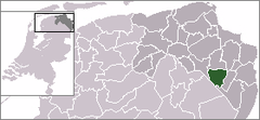
Veendam
 | |||||
| Państwo | |||||
|---|---|---|---|---|---|
| Prowincja | |||||
| Burmistrz | Sipke Swierstra (2014)[1] | ||||
| Powierzchnia | 78,71 km² | ||||
| Populacja (2006) • liczba ludności • gęstość |
| ||||
| Nr kierunkowy | 0598 | ||||
| Kod pocztowy | 9630–9633 | ||||
 | |||||
| Strona internetowa | |||||
Veendam – gmina i miasto w Holandii, w prowincji Groningen. Miasto leży pomiędzy trzema rzekami- Oude, Ooster i Westerdieg. Veendam liczy sobie 29 tys. mieszkańców. W mieście znajduje się także klub piłkarski BV Veendam.
Miasta partnerskie
Przypisy
- ↑ veendam.nl: Burgemeester. [dostęp 2014-07-13]. [zarchiwizowane z tego adresu (2014-02-20)]. (niderl.).
Linki zewnętrzne
Media użyte na tej stronie
Flag of Canada introduced in 1965, using Pantone colors. This design replaced the Canadian Red Ensign design.
Flag of the Province of Groningen, Netherlands. See for a photo of the flag. For colour conversions for Pantone were used coated instead of uncoated colours. The chart used was Commons:Pantone color chart.
Locator map of Dutch municipalities in Groningen (LocatieVeendam.png)
Autor: Erik Frohne, Licencja: CC BY-SA 3.0
Location map of province Groningen in the Netherlands
Equirectangular projection, N/S stretching 167 %. Geographic limits of the map:
- N: 53.60° N
- S: 52.80° N
- W: 6.10° E
- E: 7.30° E
Impressions of Veendam (Netherlands)
Coat of arms of the Dutch municipality of Veendam.


