Verfeil (Górna Garonna)
| miejscowość i gmina | |||
_Panorama.jpg) | |||
| |||
| Państwo | |||
|---|---|---|---|
| Region | |||
| Departament | |||
| Okręg | |||
| Kod INSEE | 31573 | ||
| Powierzchnia | 41,18 km² | ||
| Populacja (1990) • liczba ludności |
| ||
| • gęstość | 55 os./km² | ||
Położenie na mapie Górnej Garonny  | |||
Położenie na mapie Francji  | |||
Położenie na mapie Oksytanii  | |||
| 43°39′27″N 1°39′39″E/43,657500 1,660833 | |||
| Portal | |||
Verfeil – miejscowość i gmina we Francji, w regionie Oksytania, w departamencie Górna Garonna.
Według danych na rok 1990 gminę zamieszkiwało 2265 osób, a gęstość zaludnienia wynosiła 55 osób/km² (wśród 3020 gmin regionu Midi-Pireneje Verfeil plasuje się na 151. miejscu pod względem liczby ludności, natomiast pod względem powierzchni na miejscu 155.).
Zabytki
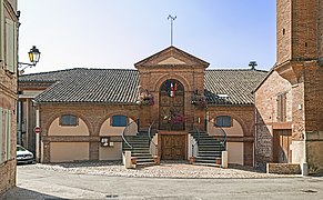
Ratusz.
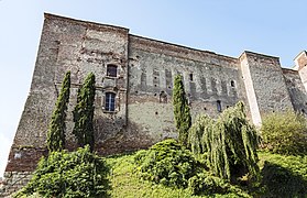
Zamek.

Brama "Vaureze".

Kościół "Św Blaise".
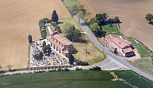
Kościół "Saint-Sernin-des-Rais".

Bibliografia
- Francuski urząd statystyczny. (fr.).
Media użyte na tej stronie
Haute-Garonne department location map.svg
Autor: Flappiefh, Licencja: CC BY-SA 4.0
Blank administrative map of the department of Haute-Garonne, France, for geo-location purpose.
Autor: Flappiefh, Licencja: CC BY-SA 4.0
Blank administrative map of the department of Haute-Garonne, France, for geo-location purpose.
France location map-Regions and departements-2016.svg
Autor: Superbenjamin, Licencja: CC BY-SA 4.0
Blank administrative map of France for geo-location purpose, with regions and departements distinguished. Approximate scale : 1:3,000,000
Autor: Superbenjamin, Licencja: CC BY-SA 4.0
Blank administrative map of France for geo-location purpose, with regions and departements distinguished. Approximate scale : 1:3,000,000
Languedoc-Roussillon-Midi-Pyrénées region location map.svg
Autor: Flappiefh, Licencja: CC BY-SA 4.0
Carte administrative vierge de la région Languedoc-Roussillon-Midi-Pyrénées, France, destinée à la géolocalisation.
Autor: Flappiefh, Licencja: CC BY-SA 4.0
Carte administrative vierge de la région Languedoc-Roussillon-Midi-Pyrénées, France, destinée à la géolocalisation.
.svg)
_-_La_porte_Vaureze.jpg)
Verfeil (Haute-Garonne) - La porte Vaureze.jpg
Autor: Didier Descouens, Licencja: CC BY-SA 4.0
This building is inscrit au titre des monuments historiques de la France. It is indexed in the base Mérimée, a database of architectural heritage maintained by the French Ministry of Culture, under the reference PA00094658 .
.
Autor: Didier Descouens, Licencja: CC BY-SA 4.0
This building is inscrit au titre des monuments historiques de la France. It is indexed in the base Mérimée, a database of architectural heritage maintained by the French Ministry of Culture, under the reference PA00094658
_-_La_mairie.jpg)
Verfeil (Haute-Garonne) - La mairie.jpg
Autor: Didier Descouens, Licencja: CC BY-SA 4.0
Verfeil, Haute-Garonne, France - Facade of town hall
Autor: Didier Descouens, Licencja: CC BY-SA 4.0
Verfeil, Haute-Garonne, France - Facade of town hall
_-_Monument_aux_morts.jpg)
Verfeil (Haute-Garonne) - Monument aux morts.jpg
Autor: Didier Descouens, Licencja: CC BY-SA 4.0
Verfeil, Haute-Garonne, France - the War memorial.
Autor: Didier Descouens, Licencja: CC BY-SA 4.0
Verfeil, Haute-Garonne, France - the War memorial.
Verfeil (Haute-Garonne) Panorama.jpg
Autor: Didier Descouens, Licencja: CC BY-SA 4.0
Verfeil, Haute-Garonne, France.
Autor: Didier Descouens, Licencja: CC BY-SA 4.0
Verfeil, Haute-Garonne, France.
_-_L%e2%80%99%c3%a9glise_Saint-Blaise.jpg)
Verfeil (Haute-Garonne) - L’église Saint-Blaise.jpg
Autor: Didier Descouens, Licencja: CC BY-SA 4.0
This building is inscrit au titre des monuments historiques de la France. It is indexed in the base Mérimée, a database of architectural heritage maintained by the French Ministry of Culture, under the reference PA00094658.
Autor: Didier Descouens, Licencja: CC BY-SA 4.0
This building is inscrit au titre des monuments historiques de la France. It is indexed in the base Mérimée, a database of architectural heritage maintained by the French Ministry of Culture, under the reference PA00094658
.svg)
_-_Le_ch%c3%a2teau.jpg)
Verfeil (Haute-Garonne) - Le château.jpg
Autor: Didier Descouens, Licencja: CC BY-SA 4.0
This building is inscrit au titre des monuments historiques de la France. It is indexed in the base Mérimée, a database of architectural heritage maintained by the French Ministry of Culture, under the reference PA00094654.
Autor: Didier Descouens, Licencja: CC BY-SA 4.0
This building is inscrit au titre des monuments historiques de la France. It is indexed in the base Mérimée, a database of architectural heritage maintained by the French Ministry of Culture, under the reference PA00094654
_-_%c3%a9glise_Saint-Sernin-des-Rais-_vue_a%c3%a9rienne.jpg)
Verfeil (Haute-Garonne) - église Saint-Sernin-des-Rais- vue aérienne.jpg
Autor: Didier Descouens, Licencja: CC BY-SA 4.0
This building is inscrit au titre des monuments historiques de la France. It is indexed in the base Mérimée, a database of architectural heritage maintained by the French Ministry of Culture, under the reference PA00094656.
Autor: Didier Descouens, Licencja: CC BY-SA 4.0
This building is inscrit au titre des monuments historiques de la France. It is indexed in the base Mérimée, a database of architectural heritage maintained by the French Ministry of Culture, under the reference PA00094656