Vijfheerenlanden
 | |||||
| Państwo | |||||
|---|---|---|---|---|---|
| Prowincja | |||||
| Burmistrz | Sjors Fröhlich | ||||
| Powierzchnia | 146,4 km² | ||||
| Populacja (2021) • liczba ludności • gęstość |
| ||||
| Nr kierunkowy | 0183, 0345, 0347 | ||||
| Kod pocztowy | 4120–4125, 4130–4146, 4163–4169, 4230–4239, 4242–4249 | ||||
| Strefa czasowa | UTC+1 | ||||
| Strona internetowa | |||||
Vijfheerenlanden – miasto i gmina w prowincji Utrecht, w Holandii[1]. Według danych na rok 2021 miasto zamieszkuje 57 829 osób, a gęstość zaludnienia wynosi 395 os./km2.
Demografia
Ludność historyczna:
| Rok | 2001 | 2008 | 2011 | 2015 | 2021 |
|---|---|---|---|---|---|
| Ludność | 53 747 | 53 650 | 53 717 | 53 917 | 57 829 |
| Gęstość zaludnienia os./km² | 367,1 | 366,4 | 366,9 | 368,3 | 395 |
Ludność według grup wiekowych na rok 2021:
| Wiek | 0–9 lat | 10–19 lat | 20–29 lat | 30–39 lat | 40–49 lat | 50–59 lat | 60–69 lat | 70–79 lat | 80–89 lat | 90+ lat |
|---|---|---|---|---|---|---|---|---|---|---|
| Liczba osób w danej grupie | 6674 | 6789 | 6765 | 7243 | 6994 | 8046 | 6944 | 5609 | 2303 | 462 |
Struktura płci na rok 2021:
| Płeć | Mężczyźni | Kobiety |
|---|---|---|
| Liczba osób w danej płci | 28 652 | 29 177 |
| Liczba osób w danej płci w % | 49,5% | 50,5% |
Klimat
Klimat jest umiarkowany[2]. Średnia temperatura wynosi 8 °C[3]. Najcieplejszym miesiącem jest lipiec (17 °C)[3], a najzimniejszym miesiącem jest luty (–2 °C)[3].
Przypisy
- ↑ GeoNames.org, www.geonames.org [dostęp 2021-07-29].
- ↑ Zaktualizowana mapa świata [dostęp 2021-07-29].
- ↑ a b c Browse datasets | NASA Earth Observations (NEO), Browse datasets | NASA Earth Observations (NEO), 29 lipca 2021 [dostęp 2021-07-29] (ang.).
Linki zewnętrzne
Media użyte na tej stronie
Coat of arms of the Dutch municipality of vijfheerenlanden
Flag of Vijfheerenlanden
Autor: Jan dijkstra, Licencja: CC BY-SA 4.0
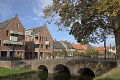
Linksaf over de mooie boogbrug ga je naar het oude centrum van de stad Vianen.


