Viking 1
| ||
 | ||
| Zaangażowani | ||
| Indeks COSPAR | 1975-075A | |
| Indeks NORAD | 08108 | |
| Rakieta nośna | Titan 3E - Centaur | |
| Miejsce startu | Cape Canaveral Air Force Station, USA | |
| Cel misji | Mars | |
| Orbita (docelowa, początkowa) | ||
| Perycentrum | 320 km | |
| Apocentrum | 56 000 km | |
| Okres obiegu | 47,26 h | |
| Czas trwania | ||
| Początek misji | 20 sierpnia 1975 | |
| Koniec misji | 17 sierpnia 1980 | |
| Wymiary | ||
| Masa całkowita | 2328 kg | |
| ||
 | ||
| Zaangażowani | ||
| Indeks COSPAR | 1975-075C | |
| Indeks NORAD | 09024 | |
| Rakieta nośna | Titan 3E Centaur | |
| Miejsce startu | Cape Canaveral Air Force Station, USA | |
| Cel misji | Mars | |
| Orbita (docelowa, początkowa) | ||
| Czas trwania | ||
| Początek misji | 20 sierpnia 1975 (21:22 UTC) | |
| Data lądowania | 20 lipca 1976 | |
| Koniec misji | 19 listopada 1982 | |
| Wymiary | ||
| Masa całkowita | 572 kg | |
Viking 1 – bezzałogowa sonda kosmiczna z programu Viking wystrzelona 20 sierpnia 1975 r. przez amerykańską agencję kosmiczną NASA.
Misja
Po wystrzeleniu przy pomocy rakiety Titan IIIE/Centaur i 10-miesięcznym locie w kierunku Marsa, orbiter zaczął przekazywać zdjęcia planety na 5 dni przed wejściem na orbitę, którą osiągnął 19 czerwca 1976. Lot sondy wymagał w początkowej fazie korekt kursu, ponieważ trajektoria nie prowadziła na orbitę Marsa, ale mijała planetę w odległości 67 000 km. Celem takiego doboru pierwotnej trajektorii było uniknięcie zderzenia drugiego stopnia rakiety z powierzchnią Marsa, co mogłoby zakłócić wyniki badań. Lądowanie na Marsie, planowane początkowo na 4 lipca, opóźniono ze względu na wykryte nierówności terenu, do czasu znalezienia bezpieczniejszego miejsca. 20 lipca lądownik Viking 1 oddzielił się od orbitera i wylądował bezpiecznie na powierzchni o 11:56:06 czasu uniwersalnego.
W pierwszej fazie lądowania, wchodząc w atmosferę, pojazd schowany za osłoną termiczną wyhamował do prędkości około 250 m/s. Na wysokości 6 km otworzył się spadochron, redukując prędkość do 60 m/s. 1,5 km nad powierzchnią Marsa uruchomione zostały rakiety spowalniające tak, że w momencie lądowania prędkość opadania wynosiła 2,4 m/s.
Rakiety hamujące posiadały 18 dysz rozpraszających gazy wylotowe na dużej powierzchni. Ograniczało to temperaturę spalin, co miało zapobiec ewentualnej sterylizacji gleby w okolicy lądowania.
Lądownik Viking 1 osiadł na równinie Chryse Planitia, czyli Złotej Równinie, której nazwa została zaczerpnięta jeszcze z prac Schiaparellego, w punkcie o współrzędnych 22,697°N szerokości i 48,222°W długości geograficznej.
Transmisja pierwszych zdjęć powierzchni nastąpiła 25 sekund po lądowaniu. Z powodu problemów z pokładowymi akumulatorami, zespół specjalistów podjął decyzję aby dokonać zmian w oprogramowaniu lądownika celem usprawnienia procesu ich ładowania. W dniu 19 listopada 1982 roku kontrola naziemna przesłała do lądownika szereg komend mających na celu wprowadzenie stosownych zmian w oprogramowaniu. Niestety część przesłanych danych przypadkowo zapisała się w komórkach pamięci w których były zapisane parametry dotyczące położenia anteny wysokiego zysku, służącej do komunikacji lądownika z kontrolą naziemną. Od tej chwili główna antena lądownika znajdowała się w bliżej nieokreślonej pozycji w stosunku do Ziemi, co uniemożliwiało prawidłową komunikację. Kontrola naziemna podejmowała szereg czynności mających na celu odzyskanie łączności z lądownikiem. W tym celu wysyłano z Ziemi nadajnikami o mocy 80 kW komendy manualnego ustawienia anteny lądownika na kierunek ku Ziemi, oraz zaprogramowanie na następne dni automatycznego procesu komunikacji lądownika z kontrolą naziemną. Pomimo kilkumiesięcznych prób, nie zdołano odebrać sygnału radiowego z lądownika. Orbiter zakończył pracę nieco wcześniej – 17 sierpnia 1980 roku, po wykonaniu 1485 okrążeń planety. Wszystkie zaplanowane eksperymenty zostały wykonane (zawiódł jedynie sejsmometr). Sukcesem zakończyły się pomiary dylatacji czasu, które okazały się zgodne z przewidywaniami ogólnej teorii względności Einsteina.

Wystrzelenie sondy Viking 1, 20 sierpnia 1975
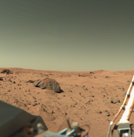
Zdjęcie zrobione przez kamerę numer 1 z lądownika Viking. Duża skała po lewej, to „Big Joe”, nazwana tak przez naukowców, ma około 2 metrów szerokości.


Zobacz też
Bibliografia
- Robert Godwin: Mars. Prószyński Media Sp. z o.o., 2011, seria: Historia podboju Kosmosu. ISBN 978-83-7839-029-9.
Linki zewnętrzne
- Viking 1 Orbiter (ang.). W: NSSDCA Master Catalog [on-line]. NASA. [dostęp 2017-06-13].
- Viking 1 Lander (ang.). W: NSSDCA Master Catalog [on-line]. NASA. [dostęp 2017-06-13].
| Trwające |
| ||||||
|---|---|---|---|---|---|---|---|
| Przeszłe |
| ||||||
| Nieudane starty | |||||||
| Przyszłe misje |
| ||||||
| Zobacz też |
![]()
Media użyte na tej stronie

The flag of Navassa Island is simply the United States flag. It does not have a "local" flag or "unofficial" flag; it is an uninhabited island. The version with a profile view was based on Flags of the World and as a fictional design has no status warranting a place on any Wiki. It was made up by a random person with no connection to the island, it has never flown on the island, and it has never received any sort of recognition or validation by any authority. The person quoted on that page has no authority to bestow a flag, "unofficial" or otherwise, on the island.

Viking 1 was launched by a Titan/Centaur rocket from Complex 41 at Cape Canaveral Air Force Station at 5:22 p.m. EDT to begin a half-billion mile, 11-month journey through space to explore Mars. The 4-ton spacecraft went into orbit around the red planet in mid-1976.

Autor: NASA on The Commons, Licencja: No restrictions
(August 27, 1976) Sand dunes and large rocks are revealed in this panoramic image of Mars taken by Viking 1's Camera 1. The horizon is approximately 3 kilometers (2 miles) away. The late afternoon sun is high in the sky over the left side of the picture. The support struts of the S-band high-gain antenna extends to the top of the picture. The American flags are located on the two RTG (Radioisotope Thermoeletric Generator) wind screens.
In the middle third of the picture the rocky surface is covered by thick deposits of wind-blown material, forming numerous dunes. At the center of the picture on the horizon are two low hills which may be part of the rim of the distant crater. Two very large rocks are visible in the middle ground; the nearer one is 3 meters (10 feet) in diameter and is 8 meters (25 feets) from the spacecraft. A cloud layer is visible halfway between the horizon and the top of the picture. The meterology boom is located right of center. Behind it, the "White Mesa" is visible.
In the nearer ground are numerous rocks about 10cm (4 inches) across, with horse-shoe shaped scour marks on their upwind side and wind tails in their lee. The fine grained material in the front of them contains small pits formed by impact of material kicked out by the lander's descent rocket engines.
nasaimages.org/luna/servlet/detail/nasaNAS~20~20~120333~2...Autor: Mark Pelligrino, Licencja: CC-BY-SA-3.0
Viking lander proof test article in the National Air and Space Museum, Smithsonian Institute, Washington, D.C.
Viking 1 launched aboard a Titan IIIE rocket August 20, 1975 and arrived at Mars on June 19, 1976. The first month was spent in orbit around the martian planet and on July 20, 1976 Viking Lander 1 separated from the Orbiter and touched down at Chryse Planitia.

Original Caption Released with NASA Image:

This picture was taken by the Viking Lander 1 on February 11, 1978 on Sol 556. The large rock just left of the center is about two meters wide. This rock was named "Big Joe" by the Viking scientists. The top of the rock is covered with red soil. Those portions of the rock not covered are similar in color to basaltic rocks on Earth. Therefore, this may be a fragment of a lava flow that was ejected by an impact crater. The part of the Lander that is visible in the lower left is the cover of the nuclear power supply.