Villahermosa
 Villahermosa | |||
| |||
| Państwo | |||
|---|---|---|---|
| Stan | |||
| Burmistrz | Gerardo Gaudiano Rovirosa | ||
| Wysokość | 10 m n.p.m. | ||
| Populacja (2010) • liczba ludności |
| ||
| Nr kierunkowy | 993 | ||
| Kod pocztowy | 86000 | ||
| Strona internetowa | |||
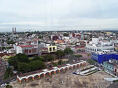
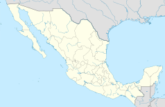
Villahermosa (hiszp. Piękne Miasto, nahuatl Cualnezcāltepēc) – meksykańskie miasto przemysłu naftowego nad rzeką Grijalva, stolica stanu Tabasco.
Do 1915 roku miasto nosiło nazwę San Juan Bautista.
Znajduje się tutaj rafineria ropy naftowej. Villahermosa leży w regionie rolniczym, w którym uprawia się kawę, kakao i trzcinę cukrową.
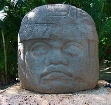
W mieście znajduje się muzeum, które zawiera pamiątki po Olmekach, a wśród nich rzeźby bazaltowych głów z La Venta o wadze 18 ton każda. W miejscu znalezienia głów i innych monolitycznych rzeźb oraz fragmentów budowli na skutek prowadzenia intensywnych poszukiwań i wydobycia ropy naftowej doszło do zniszczenia środowiska i aby te zabytki przetrwały urządzono w stolicy w 1958 roku park-muzeum.
W 2010 roku w stolicy Tabasco żyło 353 577 mieszkańców[1]. Villahermosa jest także siedzibą gminy Centro, która w 2010 roku liczyła 640 359 osób[1].
Miasta partnerskie
Zobacz też
Przypisy
- ↑ a b c Censo de Población y Vivienda 2010. Instituto Nacional de Estadística y Geografía (INEGI). [dostęp 2015-03-31]. (hiszp.).
Media użyte na tej stronie
The flag of Navassa Island is simply the United States flag. It does not have a "local" flag or "unofficial" flag; it is an uninhabited island. The version with a profile view was based on Flags of the World and as a fictional design has no status warranting a place on any Wiki. It was made up by a random person with no connection to the island, it has never flown on the island, and it has never received any sort of recognition or validation by any authority. The person quoted on that page has no authority to bestow a flag, "unofficial" or otherwise, on the island.
Autor: Spischot, Licencja: CC-BY-SA-3.0
Location Map of Tabasco
Equirectangular projection, Geographic limits of the map:
- N: 19.00° N
- S: 16.90° N
- W: 94.20° W
- E: 90.50° W
Autor: Glysiak, Licencja: CC BY-SA 4.0
Head of Olmeca in Villhermosa Museum
Coat of arms of Tabasco
Autor: Giovanni Alfredo Garciliano Diaz, Licencja: CC0
Flag of Villahermosa, Tabasco
Flag of Tabasco


