Villalbilla
| |||||
 | |||||
| Państwo | |||||
| Wspólnota autonomiczna | |||||
| Burmistrz | Iván Jesús Borrego Holgado (PP) | ||||
| Powierzchnia | 34,6 km² | ||||
| Wysokość | 747 m n.p.m. | ||||
| Populacja (2009) • liczba ludności • gęstość | 8 923 257,89 os./km² | ||||
| Kod pocztowy | 28810 | ||||
| Tablice rejestracyjne | M | ||||
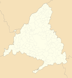
Położenie na mapie wspólnoty autonomicznej Madrytu (c) Miguillen, CC BY-SA 3.0 | |||||
| Strona internetowa | |||||
| Portal | |||||
Villalbilla – miasto w Hiszpanii we wspólnocie autonomicznej Madryt, 42 km od Madrytu. Składa się z dwóch sąsiednich gmin Villalbilla i Los Hueros, przy czym oficjalnie miasto występuje pod nazwą Villalbilla.
Media użyte na tej stronie
Autor: NordNordWest, Licencja: CC BY-SA 3.0
Location map of Spain
Equirectangular projection, N/S stretching 130 %. Geographic limits of the map:
- N: 44.4° N
- S: 34.7° N
- W: 9.9° W
- E: 4.8° E
Autor: Pedro A. Gracia Fajardo, escudo de Manual de Imagen Institucional de la Administración General del Estado, Licencja: CC0
Flaga Hiszpanii
Autor: Heralder, Licencja: CC BY-SA 4.0
Coat of arms of Villalbilla, Community of Madrid (Spain)
Autor: Dirección General de Turismo. Consejería de Economía e Innovación Tecnológica. Comunidad de Madrid., Licencja: CC BY 3.0 es
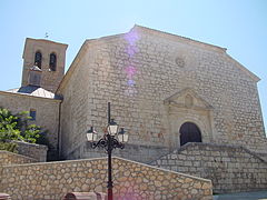
Iglesia en Villalbilla.
Autor: See file history, Licencja: CC0
Flag of the Community of Madrid (Spain)


