Villefranche-sur-Saône
| miejscowość i gmina | |||
 Villefranche-sur-Saône, 2008 | |||
| |||
| Państwo | |||
|---|---|---|---|
| Region | |||
| Departament | |||
| Okręg | |||
| Kod INSEE | 69264 | ||
| Powierzchnia | 9,48 km² | ||
| Populacja (1990) • liczba ludności |
| ||
| • gęstość | 3116 os./km² | ||
| Kod pocztowy | 69400 | ||
Położenie na mapie Rodanu  | |||
Położenie na mapie Francji  | |||
Położenie na mapie regionu Owernia-Rodan-Alpy  | |||
| Strona internetowa | |||
| Portal | |||
Villefranche-sur-Saône – miejscowość i gmina we Francji, w regionie Owernia-Rodan-Alpy, w departamencie Rodan.
Według danych na rok 1990 gminę zamieszkiwały 29 542 osoby, a gęstość zaludnienia wynosiła 3116 osób/km² (wśród 2880 gmin regionu Rodan-Alpy Villefranche-sur-Saône plasuje się na 22. miejscu pod względem liczby ludności, natomiast pod względem powierzchni na miejscu 1161.).
Galeria
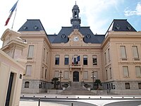
Ratusz, 2012

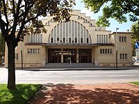
Dworzec kolejowy, 2008
Hala targowa, 2012
Bibliografia
- Francuski urząd statystyczny. (fr.).
Linki zewnętrzne
Media użyte na tej stronie
Département du Rhone location map.svg
Autor: Flappiefh, Licencja: CC BY-SA 4.0
carte de géolocalisation du département du Rhône sans la métropole de Lyon
Autor: Flappiefh, Licencja: CC BY-SA 4.0
carte de géolocalisation du département du Rhône sans la métropole de Lyon
Limites géographiques de la carte :
- West: 4.169 E
- East: 5.244 E
- North: 46.368 N
- South: 45.393 N
France location map-Regions and departements-2016.svg
Autor: Superbenjamin, Licencja: CC BY-SA 4.0
Blank administrative map of France for geo-location purpose, with regions and departements distinguished. Approximate scale : 1:3,000,000
Autor: Superbenjamin, Licencja: CC BY-SA 4.0
Blank administrative map of France for geo-location purpose, with regions and departements distinguished. Approximate scale : 1:3,000,000
Auvergne-Rhône-Alpes region location map.svg
Autor: Flappiefh, Licencja: CC BY-SA 4.0
Carte administrative vierge de la région Auvergne-Rhône-Alpes, France, destinée à la géolocalisation.
Autor: Flappiefh, Licencja: CC BY-SA 4.0
Carte administrative vierge de la région Auvergne-Rhône-Alpes, France, destinée à la géolocalisation.
.svg)
.svg)

Marché couvert de Villefranche.jpg
Autor: Saturnyn, Licencja: CC BY-SA 3.0
Marché couvert de Villefranche
Autor: Saturnyn, Licencja: CC BY-SA 3.0
Marché couvert de Villefranche

Gare de Villefranche sur Saône.JPG
Autor: Florian Pépellin, Licencja: CC BY-SA 3.0
Front of the train station of the French commune of Villefranche sur Saône in the department of Rhône.
Autor: Florian Pépellin, Licencja: CC BY-SA 3.0
Front of the train station of the French commune of Villefranche sur Saône in the department of Rhône.

Hôtel de ville de Villefranche.jpg
Autor: Saturnyn, Licencja: CC BY-SA 3.0
Hôtel de ville de Villefranche
Autor: Saturnyn, Licencja: CC BY-SA 3.0
Hôtel de ville de Villefranche

Flag of the region Auvergne-Rhône-Alpes.svg
Flag of the French administrative region Auvergne-Rhône-Alpes
Flag of the French administrative region Auvergne-Rhône-Alpes
Villefranche panorama.jpg
Autor: Kryptonian, Licencja: CC BY-SA 3.0
Panorama de Villefranche-sur-Saône.
Autor: Kryptonian, Licencja: CC BY-SA 3.0
Panorama de Villefranche-sur-Saône.