Vinça
| miejscowość i gmina | |||
 Vinça (2008) | |||
| |||
| Państwo | |||
|---|---|---|---|
| Region | |||
| Departament | |||
| Okręg | |||
| Kod INSEE | 66230 | ||
| Powierzchnia | 7,7 km² | ||
| Populacja (1990) • liczba ludności |
| ||
| • gęstość | 214 os./km² | ||
| Kod pocztowy | 66320 | ||
Położenie na mapie Pirenejów Wschodnich  © Hawk-Eye, CC BY-SA 3.0 | |||
Położenie na mapie Francji  | |||
Położenie na mapie Oksytanii  | |||
| Strona internetowa | |||
| Portal | |||
Vinça (kat.: Vinçà) – miejscowość i gmina we Francji, w regionie Oksytania, w departamencie Pireneje Wschodnie. Zajmuje powierzchnię 7,7 km². W 2012 roku liczyła 1947 mieszkańców, a gęstość zaludnienia wynosiła 251,6 osób/km²[1].

Vinça (2011)
Zabytki
Zabytki na terenie gminy posiadające status monument historique[2]:
- krzyż cmantarny (Croix de cimetière de Vinça)
- krzyż Noell (Croix Noell)
- kościół świętych Juliana i Bazylissy (Église Saint-Julien-et-Sainte-Baselisse de Vinça)
- kościół św. Piotra de Belloch (Église Saint-Pierre de Belloch)

Krzyż cmantarny (2013)

Krzyż Noell (2015)
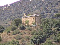
Kościół św. Piotra de Belloch (2005)
Populacja

Populacja Vinça w latach 1962–2008
Przypisy
- ↑ Commune de Vinça (66230). INSEE. [dostęp 2016-06-17]. (fr.).
- ↑ Monuments historiques de Pyrénées-Orientales. culture.gouv.fr. [dostęp 2016-06-17]. (fr.).
Bibliografia
- Francuski urząd statystyczny. (fr.).
Linki zewnętrzne
Media użyte na tej stronie
France location map-Regions and departements-2016.svg
Autor: Superbenjamin, Licencja: CC BY-SA 4.0
Blank administrative map of France for geo-location purpose, with regions and departements distinguished. Approximate scale : 1:3,000,000
Autor: Superbenjamin, Licencja: CC BY-SA 4.0
Blank administrative map of France for geo-location purpose, with regions and departements distinguished. Approximate scale : 1:3,000,000
Languedoc-Roussillon-Midi-Pyrénées region location map.svg
Autor: Flappiefh, Licencja: CC BY-SA 4.0
Carte administrative vierge de la région Languedoc-Roussillon-Midi-Pyrénées, France, destinée à la géolocalisation.
Autor: Flappiefh, Licencja: CC BY-SA 4.0
Carte administrative vierge de la région Languedoc-Roussillon-Midi-Pyrénées, France, destinée à la géolocalisation.
.svg)
Population - Municipality code 66230.svg
Autor: Michiel1972, Licencja: CC BY-SA 3.0
Autor: Michiel1972, Licencja: CC BY-SA 3.0
Population - Municipality code 66230.svg
Population Census 1962-2008
501.jpg.croix Noell.jpg
Autor: Meria Geoian, Licencja: CC BY-SA 4.0
there remains only the base,the cross has been changed, Vinça
Autor: Meria Geoian, Licencja: CC BY-SA 4.0
there remains only the base,the cross has been changed, Vinça

Croix de cimetière, Vinça.jpg
Autor: Meria z Geoian, Licencja: CC BY-SA 3.0
This building is classé au titre des monuments historiques de la France. It is indexed in the base Mérimée, a database of architectural heritage maintained by the French Ministry of Culture, under the reference PA00104178 .
.
Autor: Meria z Geoian, Licencja: CC BY-SA 3.0
This building is classé au titre des monuments historiques de la France. It is indexed in the base Mérimée, a database of architectural heritage maintained by the French Ministry of Culture, under the reference PA00104178
Pantà de vinçà.JPG
Vinçà, county Conflent, French Catalonia.
Vinçà, county Conflent, French Catalonia.
Pyrénées-Orientales department location map.svg
© Hawk-Eye, CC BY-SA 3.0
Blank administrative map of the department of Pyrénées-Orientales, France, for geo-location purpose.
© Hawk-Eye, CC BY-SA 3.0
Blank administrative map of the department of Pyrénées-Orientales, France, for geo-location purpose.
.svg)

Chapelle San Pere de Belloc.jpg
Autor: Judy12, Licencja: CC BY-SA 3.0
This building is inscrit au titre des monuments historiques de la France. It is indexed in the base Mérimée, a database of architectural heritage maintained by the French Ministry of Culture, under the reference PA00104177.
Autor: Judy12, Licencja: CC BY-SA 3.0
This building is inscrit au titre des monuments historiques de la France. It is indexed in the base Mérimée, a database of architectural heritage maintained by the French Ministry of Culture, under the reference PA00104177