Vlasotince
| |||||
 | |||||
| Państwo | |||||
| Okręg | jablanicki | ||||
| Gmina | Vlasotince | ||||
| Burmistrz | Srđan Šušulić | ||||
| Powierzchnia | 308 km² | ||||
| Populacja (2011) • liczba ludności | 15 882[1] | ||||
| Nr kierunkowy | +381 16 | ||||
| Kod pocztowy | 16210 | ||||
| Tablice rejestracyjne | LE | ||||
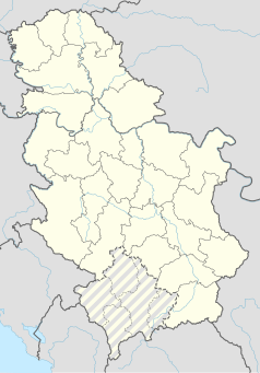
Położenie na mapie Serbii (c) Karte: NordNordWest, Lizenz: Creative Commons by-sa-3.0 de | |||||
| Strona internetowa | |||||
Vlasotince (cyr. Власотинце) – miasto w Serbii, w okręgu jablanickim, siedziba gminy Vlasotince. W 2011 roku liczyło 15 882 mieszkańców[1].
Przypisy
- ↑ a b Popis stanovništva, domaćinstava i stanova 2011. u Republici Srbiji (serb.). Republički zavod za statistiku. [dostęp 2019-08-1e].
Media użyte na tej stronie
Serbia adm location map.svg
(c) Karte: NordNordWest, Lizenz: Creative Commons by-sa-3.0 de
Location map of Serbia
(c) Karte: NordNordWest, Lizenz: Creative Commons by-sa-3.0 de
Location map of Serbia
Grb Vlasotinca.png
Coat of arms of Vlasotince
Coat of arms of Vlasotince
Zastava Vlasotinca.png
Flag of Vlasotince
Flag of Vlasotince
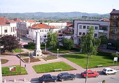
Vlasotince town centre1.jpg
Autor: Vl, Licencja: CC-BY-SA-3.0
Vlasotince, south-east Serbia, town centre, town center, WW I monument, former Turkish administrative building, Ottoman Empire fortification, museum .
Autor: Vl, Licencja: CC-BY-SA-3.0
Vlasotince, south-east Serbia, town centre, town center, WW I monument, former Turkish administrative building, Ottoman Empire fortification, museum .


