Wadmalaw Island
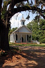
 Kaplica na Wadmalaw Island | |
| Kontynent | |
|---|---|
| Państwo | |
| Stan | |
| Akwen | |
| Powierzchnia | 108,5 km² |
| Populacja (2000) • liczba ludności • gęstość |
|
Wadmalaw Island - jedna z wysp należących do Sea Islands, leżąca u wybrzeży Karoliny Południowej w hrabstwie Charleston. Leży na południowy zachód od James Island, która w ponad połowie ja otacza i około 11 km od Charleston. Na wyspie w 2000 było 2611 mieszkańców[1].
Pierwsi angielscy koloniści przybyli do Południowej Karoliny w 1670 roku, zanim przenieśli się na miejsce obecnego Charleston, spędzili na Wadmalaw Island pierwsze 4 lata pobytu, przymierając głodem. Przeżyli dzięki wspaniałomyślności tubylców, Indian Guale, którzy dzielili z nimi kukurydzę i fasolę[2].
W latach 1960-1987 firma The Lipton Tea Company prowadziła eksperymentalną plantację herbaty, która po sprzedaży funkcjonuje do dnia dzisiejszego jak plantacja produkcyjna.
Przypisy
- ↑ a b Population - American Cenzus Bureau. [dostęp 2011-06-06]. [zarchiwizowane z tego adresu (2020-02-11)]. (ang.).
- ↑ Zepke, Terrance. Coastal South Carolina: Welcome to the Low Country. Pineapple Press, Inc., 2006. ISBN 1-56164-348-3 p. 155
Media użyte na tej stronie
Autor: Uwe Dedering, Licencja: CC BY-SA 3.0
Relief location map of the USA (without Hawaii and Alaska).
EquiDistantConicProjection : Central parallel :
* N: 37.0° N
Central meridian :
* E: 96.0° W
Standard parallels:
* 1: 32.0° N
* 2: 42.0° N
Made with Natural Earth. Free vector and raster map data @ naturalearthdata.com.
Formulas for x and y:
x = 50.0 + 124.03149777329222 * ((1.9694462586094064-({{{2}}}* pi / 180))
      * sin(0.6010514667026994 * ({{{3}}} + 96) * pi / 180))
y = 50.0 + 1.6155950752393982 * 124.03149777329222 * 0.02613325650382181
      - 1.6155950752393982  * 124.03149777329222 *
     (1.3236744353715044  - (1.9694462586094064-({{{2}}}* pi / 180))
      * cos(0.6010514667026994 * ({{{3}}} + 96) * pi / 180))
The flag of Navassa Island is simply the United States flag. It does not have a "local" flag or "unofficial" flag; it is an uninhabited island. The version with a profile view was based on Flags of the World and as a fictional design has no status warranting a place on any Wiki. It was made up by a random person with no connection to the island, it has never flown on the island, and it has never received any sort of recognition or validation by any authority. The person quoted on that page has no authority to bestow a flag, "unofficial" or otherwise, on the island.
Autor: SANtosito, Licencja: CC BY-SA 4.0
Relief location map of South Carolina, USA
Geographic limits of the map:
- N: 35.4° N
- S: 31.8° N
- W: 83.6° W
- E: 78.3° W
Autor: Galen Parks Smith, Licencja: CC BY-SA 3.0
Grace Chapel, circa 1840, Wadmalaw Island South Carolina.


