Waiheke
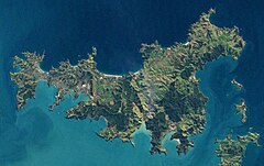
 Zdjęcie satelitarne wyspy | |
| Kontynent | Australia i Oceania |
|---|---|
| Państwo | |
| Akwen | zatoka Hauraki |
| Powierzchnia | 92 km² |
| Najwyższy punkt | 231 m n.p.m. |
| Populacja (2013) • liczba ludności • gęstość |
|
Waiheke (ang. Waiheke Island) – wyspa w Nowej Zelandii, w regionie administracyjnym Auckland, u północnego wybrzeża Wyspy Północnej, na zatoce Hauraki[1].
Wyspa liczy około 20 km długości i do 10 km szerokości. Powierzchnia wyspy wynosi 92 km² (piąta pod względem wielkości wyspa w kraju). Znaczną część wyspy zajmują wzgórza, o wysokości nieprzekraczającej 231 m n.p.m[1][2].
W XIX wieku na Waiheke eksploatowano złoża manganu. Współcześnie wyspa jest ośrodkiem turystyki, a w jej zachodniej części dominuje zabudowa mieszkalna. Prowadzona jest tu uprawa winorośli oraz hodowla owiec i bydła[1][2]. W 2013 roku liczba ludności wynosiła 8259[3].
Wyspa ma połączenie promowe z oddalonym o około 20 km na zachód miastem Auckland[1][3].
Przypisy
- ↑ a b c d Waiheke Island, [w:] Encyclopædia Britannica [online] [dostęp 2018-05-08] (ang.).
- ↑ a b Waiheke Island. [w:] 1966 Encyclopaedia of New Zealand [on-line]. Te Ara. [dostęp 2018-05-08]. (ang.).
- ↑ a b Story: Auckland places – Gulf islands. Te Ara Encyclopedia of New Zealand. [dostęp 2018-05-08]. (ang.).
Media użyte na tej stronie
Flag of New Zealand. Specification: http://www.mch.govt.nz/nzflag/description.html , quoting New Zealand Gazette, 27 June 1902.
Landsat 7 image of Auckland, New Zealand, from NASA's Earth Observatory - cropped to show just Waiheke Island.
Original caption (for full image - and not entirely accurate): Auckland, New Zealand’s largest city, is located on the country’s North Island. Nearly a third of New Zealand’s population lives in Auckland—just over one million people. This natural-color (photo-like) image of Auckland was acquired on August 27, 2002, by NASA’s Landsat 7 satellite. The most densely developed areas appear white and gray, while suburban areas appear grayish green—a mixture of houses, streets, and lawns. The city spreads out across various peninsulas surrounding Tamaki Strait and other bays and inlets.
The city has been built up around the Auckland Volcanic Field; within a 20-kilometer (12.4-mile) radius of the heart of the city, there are 49 volcanoes, most of them small cones less than 150 meters (492 feet) high. Many of them have been protected as parks or non-residential development, such as ball fields, and so they stand out as green circles of vegetation against the surrounding gray and white cityscape. A few of the most distinct of these urban volcanoes are labeled in this image: Mt. Eden, One Tree Hill, and Mt. Wellington. Among the largest of the volcanoes is Rangitoto Island, which sits offshore of the city between the waters of Tamaki Strait and Hauraki Gulf.
The last eruption in this volcanic field appears to have occurred about 600 years ago. The nature of volcanic activity in the area is different from the subduction-driven volcanism elsewhere on the North Island, such as at Mount Ruapehu. It results from the city’s location above a mantle plume, a hot spot about 100 kilometers below ground where temperatures are high enough to melt rock. The melted rock has a low viscosity, and it flows easily up through the overlying rock.
References:
- Smith, I., and Allen, S. (n.d.). Volcanic Hazards: Auckland Volcanic Field. New Zealand Volcanoes: Booklet 5: Auckland Volcanic Field. Produced by the Volcanic Hazards Working Group of the Civil Defence Scientific Advisory Committee. Accessed March 2, 2009.
- Wikipedia. (2009, March 1). Auckland. Accessed March 2, 2009.
NASA image created by Jesse Allen, using Landsat data provided by the United States Geological Survey. Caption by Rebecca Lindsey.
Instrument: Landsat 7 - ETM+Autor:
- New_Zealand_location_map.svg: NordNordWest
- derivative work: Виктор В (talk)
Location map of New Zealand


