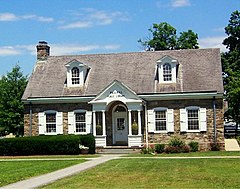
Wallkill (Nowy Jork)
| ||
(c) Daniel Case, CC-BY-SA-3.0 Biblioteka Publiczna | ||
| Państwo | ||
|---|---|---|
| Stan | ||
| Hrabstwo | Ulster | |
| Powierzchnia | 8 km² | |
| Populacja (2010) • liczba ludności • gęstość | 2288 280 os./km² | |
| Nr kierunkowy | 845 | |
| Kod pocztowy | 12589 | |
Położenie na mapie stanu Nowy Jork (c) NordNordWest, CC BY 3.0 | ||
| Portal | ||
Wallkill – jednostka osadnicza w stanie Nowy Jork, w hrabstwie Ulster.
Powierzchnia Wallkill wynosi 8 km², zamieszkiwane jest przez 2288 mieszkańców (2010)[1]. Obok Wallkill płynie rzeka o tej samej nazwie.
Ok. 5 km na północny zachód od centrum Wallkill znajdują się Farmy Strażnicy wraz z drukarnią[2], jest to największy na świecie kompleks budynków należący do Świadków Jehowy, mieszka w nim ponad 1600 wolontariuszy[3]. W latach 1988-1995 mieściła się tutaj Biblijna Szkoła Strażnicy – Gilead[4], a w roku w 1978 roku zaprojektowano tutaj MEPS[2].
Przypisy
- ↑ American FactFinder, United States Census Bureau [dostęp 2014-10-09] [zarchiwizowane z adresu 2015-01-18].
- ↑ a b Watchtower, Farmy Strażnicy — pół wieku pracy żniwnej, jw.org [dostęp 2014-10-09].
- ↑ Watchtower, Prace w Wallkill i Warwick posuwają się naprzód, jw.org [dostęp 2014-10-09].
- ↑ Watchtower, Siedemdziesiąt lat Szkoły Gilead, jw.org [dostęp 2014-10-09].
Media użyte na tej stronie
(c) NordNordWest, CC BY 3.0
Location map of the State of New York, USA
Autor: Uwe Dedering, Licencja: CC BY-SA 3.0
Location map of the USA (without Hawaii and Alaska).
EquiDistantConicProjection:
Central parallel:
* N: 37.0° N
Central meridian:
* E: 96.0° W
Standard parallels:
* 1: 32.0° N
* 2: 42.0° N
Made with Natural Earth. Free vector and raster map data @ naturalearthdata.com.
Formulas for x and y:
x = 50.0 + 124.03149777329222 * ((1.9694462586094064-({{{2}}}* pi / 180))
      * sin(0.6010514667026994 * ({{{3}}} + 96) * pi / 180))
y = 50.0 + 1.6155950752393982 * 124.03149777329222 * 0.02613325650382181
      - 1.6155950752393982  * 124.03149777329222 *
     (1.3236744353715044  - (1.9694462586094064-({{{2}}}* pi / 180))
      * cos(0.6010514667026994 * ({{{3}}} + 96) * pi / 180))
The flag of Navassa Island is simply the United States flag. It does not have a "local" flag or "unofficial" flag; it is an uninhabited island. The version with a profile view was based on Flags of the World and as a fictional design has no status warranting a place on any Wiki. It was made up by a random person with no connection to the island, it has never flown on the island, and it has never received any sort of recognition or validation by any authority. The person quoted on that page has no authority to bestow a flag, "unofficial" or otherwise, on the island.


