Walthamstow
| Dzielnica Londynu | |
 Domy rodzinne w zabudowie szeregowej, budownictwo typowe dla Walthamstow | |
| Państwo | |
|---|---|
| Kraj | |
| Region | Wielki Londyn |
| Miasto | Londyn |
| Gmina | Waltham Forest |
| Kod pocztowy | E17 |
Położenie na mapie Wielkiego Londynu  Contains Ordnance Survey data © Crown copyright and database right, CC BY-SA 3.0 | |
Położenie na mapie Wielkiej Brytanii  (c) Karte: NordNordWest, Lizenz: Creative Commons by-sa-3.0 de | |
Położenie na mapie Anglii  | |
| 51°35′02″N 0°01′16″W/51,584000 -0,021100 | |
| Portal | |
Walthamstow – dzielnica Londynu, leżąca w gminie Waltham Forest[1], położona w odległości 12,1 km od centrum Londynu (Charing Cross). Wchodzi w skład okręgu wyborczego Walthamstow. Posiada kod pocztowy E17. W 2011 roku dzielnica liczyła 111263 mieszkańców[2]. Na terenie dzielnicy znajduje się najdłuższy w Europie targ uliczny, Walthamstow Market[3].
Historia
Dzielnica oryginalnie nazywana była "Wilcumestowe"[4], a w Domesday Book (1086) wspomniana jest jako "Wilcumestou". Początkowo tworzyło ją pięć małych wiosek, choć w drugiej połowie XIX wieku rozrosła się do rozmiaru przedmieścia Londynu. Pod koniec wieku populacja Walthamstow zaczęła szybko rosnąć. Wybudowano wówczas wiele nowych budynków, a także postawiono ratusz. Wcześniej część hrabstwa Essex, w 1965 roku Walthamstow zostało włączone do Londynu jako część gminy Waltham Forest.
Na skutek Letnich Igrzysk Olimpijskich w 2012 roku, odbywających się w pobliskiej dzielnicy Stratford, zainteresowanie Walthamstow znacznie wzrosło. Obecnie dzielnica przechodzi proces gentryfikacji.
Galeria
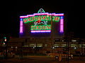
Od lewej: ratusz gminy Waltham Forest, muzeum Williama Morrisa, targ uliczny na High Street, pub Ye Olde Rose & Crown, stadion Walthamstow.
 (c) Julian Osley, CC BY-SA 2.0
 (c) Claire Ward, CC BY-SA 2.0
Przypisy
- ↑ Geograph Britain and Ireland - photograph every grid square! (ang.). www.geograph.org.uk. [dostęp 2015-03-28].
- ↑ Area: Walthamstow (Westminster Parliamentary Constituency) (ang.). www.neighbourhood.statistics.gov.uk. [dostęp 2015-03-28]. [zarchiwizowane z tego adresu (2017-02-11)].
- ↑ Walthamstow Market | Shopping in Walthamstow, London (ang.). www.timeout.com. [dostęp 2017-02-11].
- ↑ How The London Boroughs Got Their Names (ang.). londonist.com. [dostęp 2017-02-10].
Media użyte na tej stronie
Contains Ordnance Survey data © Crown copyright and database right, CC BY-SA 3.0
Map of Greater London, UK with the following information shown:
- Administrative borders
- Coastline, lakes and rivers
- Roads and railways
- Urban areas
The data includes both primary routes and railway lines.
Equirectangular map projection on WGS 84 datum, with N/S stretched 160%
Geographic limits:
- West: 0.57W
- East: 0.37E
- North: 51.72N
- South: 51.25N
(c) Karte: NordNordWest, Lizenz: Creative Commons by-sa-3.0 de
Location map of the United Kingdom


Flag of England. Saint George's cross (a red cross on a white background), used as the Flag of England, the Italian city of Genoa and various other places.

Autor: Spudgun67, Licencja: CC BY-SA 4.0
William Morris 1834-1896 lived here 1848-1856. Edward Lloyd Publisher lived here 1857-1885 - The William Morris Gallery, Lloyd Park, Forest Road, Walthamstow, London E17 4PP
.jpg)
Autor: Ewan Munro from London, UK, Licencja: CC BY-SA 2.0
One of the best pubs in the area. A proper boozer, decent beer, large place.
Address: 55 Hoe Street (formerly Green Leaf Lane). Former Name(s): The Rose and Crown. Owner: Enterprise Inns (website); Scottish and Newcastle (former); Truman Hanbury Buxton (former). Links:
London Pubology
(c) Claire Ward, CC BY-SA 2.0
Walthamstow High Street. In the very bottom right of the grid square looking south west. Walthamstow market runs the whole length of the high street and is probably the longest street market in Europe.
Autor: ProfDEH, Licencja: CC BY-SA 3.0
Typical terraced houses in Walthamstow, London

Autor: Acabashi, Licencja: CC BY-SA 4.0
The February 2016 newly refurbished neon light frontage of the old Walthamstow Greyhound Stadium in the Borough of Waltham Forest, London. England.
The greyhound stadium was closed in 2008, and has been redeveloped as 'Stadium Place,' and will include residential housing, markets and malls. The front range of the stadium, which includes the neon lighting, is Grade II listed. The photograph is taken from Walthamstow Avenue across the A12 Chingford Mount Road.
Camera: Canon EOS 6D with Canon EF 24-105mm F4L IS USM lens.
Software: large RAW file lens-corrected, optimized and downsized with DxO OpticsPro 10 Elite, Viewpoint 2.
.jpg)
(c) Julian Osley, CC BY-SA 2.0
This is a photo of listed building number