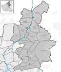
Wandsbek (okręg administracyjny)
 | |||
| |||
| Państwo | |||
|---|---|---|---|
| Kraj związkowy | |||
| Powierzchnia | 147,60 km² | ||
| Populacja (31 grudnia 2011) • liczba ludności • gęstość |
| ||
| Nr kierunkowy | 040 | ||
| Kod pocztowy | 22041-22089 | ||
| Tablice rejestracyjne | HH | ||
| Podział miasta | 18 dzielnic | ||
| 53°34′55″N 10°05′03″E/53,581944 10,084167 | |||
| Strona internetowa | |||
| Portal | |||
Wandsbek, Bezirk Wandsbek – okręg administracyjny w północno-wschodniej części Hamburga. Z ponad 416 tysiącami mieszkańców jest najliczniejszym okręgiem Hamburga. W jego skład wchodzi 18 dzielnic.
Dzielnice
W skład okręgu wchodzi 18 dzielnic (Stadtteil):
- Bergstedt
- Bramfeld
- Duvenstedt
- Eilbek
- Farmsen-Berne
- Hummelsbüttel
- Jenfeld
- Lemsahl-Mellingstedt
- Marienthal
- Poppenbüttel
- Rahlstedt
- Sasel
- Steilshoop
- Tonndorf
- Volksdorf
- Wandsbek
- Wellingsbüttel
- Wohldorf-Ohlstedt
Media użyte na tej stronie
Autor: Staro1, Licencja: CC-BY-SA-3.0
Stormarnhaus in Hamburg-Wandsbek. Ehemaliger Sitz der Verwaltung des Kreises Stormarn, heute Sitz der Wandsbeker Bezirksverwaltung. Das Gebäude wurde 1922/23 von Fritz Höger erbaut.
Historical Coat of arms of Wandsbek - The shield with the swan is the arms of the Stormarn territory, the other elements refer to the famous Wandsbeck Messenger, Mathias Claudius (1740-1815).
Autor: TUBS
Location of borough xy (see filename) in Hamburg.


