Wanstead (stacja metra)
 | |
| Państwo | |
|---|---|
| Miejscowość | Londyn |
| Dzielnica | Wanstead |
| Data otwarcia | 1947 |
| Liczba peronów | 2 |
| Central Line | |
| Poprzednia stacja | Leytonstone |
| Następna stacja | Redbridge |
Położenie na mapie gminy Redbridge  Contains Ordnance Survey data © Crown copyright and database right, CC BY-SA 3.0 | |
Położenie na mapie Wielkiej Brytanii  (c) Karte: NordNordWest, Lizenz: Creative Commons by-sa-3.0 de | |
Położenie na mapie Anglii  | |
Położenie na mapie Wielkiego Londynu  Contains Ordnance Survey data © Crown copyright and database right, CC BY-SA 3.0 | |
| Portal | |
Wanstead – stacja londyńskiego metra położona na trasie Central Line pomiędzy stacjami Leytonstone a Redbridge. Znajduje się w dzielnicy Wanstead w gminie London Borough of Redbridge, w czwartej strefie biletowej[1]. Stacja funkcjonuje od 14 grudnia 1947[2] W 2010 roku obsłużyła 2,200 miliona pasażerów[3].
Połączenia
Stacja obsługiwana jest przez autobusy 101 i 308, oraz nocne N8 i N55.
Galeria
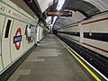
Platfoma w kierunku wschodnim

Platfoma w kierunku zachodnim

Symbol stacji
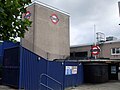
Południowe wejście
Przypisy
- ↑ Tube stations - Wanstead. Transport for London. [dostęp 2012-01-04].
- ↑ Central line facts (ang.). Transport For London. [dostęp 2012-01-04].
- ↑ Customer metrics: entries and exits (ang.). Transport For London. [dostęp 2012-01-04].
| Linia główna | |
|---|---|
| Odgałęzienie West Ruislip | |
| Odgałęzienie Ealing Broadway | |
| Odgałęzienie Woodford | |
| Odgałęzienie Epping |
![]()
Media użyte na tej stronie
(c) Karte: NordNordWest, Lizenz: Creative Commons by-sa-3.0 de
Location map of the United Kingdom


Autor: Sunil060902, Licencja: CC BY-SA 3.0
Wanstead tube station viewed from the northwest, showing the northern entrance.

Autor: Sunil060902, Licencja: CC BY-SA 3.0
Wanstead tube station viewed from the southwest, showing southern entrance on the right.
Contains Ordnance Survey data © Crown copyright and database right, CC BY-SA 3.0
Blank map of the London Borough of Redbridge, showing electoral wards.
Equirectangular map projection on WGS 84 datum, with N/S stretched 160%
Geographic limits:
- West: 0
- East: 0.16E
- North: 51.635N
- South: 51.535N

Autor: Sunil060902, Licencja: CC BY-SA 3.0
Wanstead tube station westbound platform looking west

Autor: Sunil060902, Licencja: CC BY-SA 3.0
Wanstead tube station westbound platform looking east
Contains Ordnance Survey data © Crown copyright and database right, CC BY-SA 3.0
Map of Greater London, UK with the following information shown:
- Administrative borders
- Coastline, lakes and rivers
- Roads and railways
- Urban areas
The data includes both primary routes and railway lines.
Equirectangular map projection on WGS 84 datum, with N/S stretched 160%
Geographic limits:
- West: 0.57W
- East: 0.37E
- North: 51.72N
- South: 51.25N

Autor: Sunil060902, Licencja: CC BY-SA 3.0
Platform roundel on Wanstead station