Warrington (borough)
| ||||
| ||||
 | ||||
| Państwo | ||||
| Kraj | ||||
| Region | North West England | |||
| Hrabstwo | Cheshire | |||
| Powierzchnia | 181 km² | |||
| Populacja (2016) • liczba ludności | 208 809[1] | |||
| • gęstość | 1154 os./km² | |||
| Położenie na mapie Cheshire Contains Ordnance Survey data © Crown copyright and database right, CC BY-SA 3.0 | ||||
| Strona internetowa | ||||
| Portal | ||||
Warrington – dystrykt (unitary authority) w hrabstwie ceremonialnym Cheshire w Anglii.
Miasta
Civil parishes
- Appleton, Birchwood, Burtonwood and Westbrook, Croft, Cuerdley, Culcheth and Glazebury, Grappenhall and Thelwall, Great Sankey, Hatton, Lymm, Penketh, Poulton-with-Fearnhead, Rixton-with-Glazebrook, Stockton Heath, Stretton, Walton, Winwick i Woolston[2].
Przypisy
- ↑ Population Estimates for UK, England and Wales, Scotland and Northern Ireland - Office for National Statistics, www.ons.gov.uk [dostęp 2017-10-21] (ang.).
- ↑ Ordnance Survey linked data
Media użyte na tej stronie
Flag of England.svg
Flag of England. Saint George's cross (a red cross on a white background), used as the Flag of England, the Italian city of Genoa and various other places.
Flag of England. Saint George's cross (a red cross on a white background), used as the Flag of England, the Italian city of Genoa and various other places.
The Skittles, Warrington, March 2011jpg.jpg
Autor:
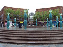
"The Skittles" sculpture at Warrington town centre, Cheshire.
Autor:
- Warrington_town_centre_-_DSC05908.JPG: Green Lane
- derivative work: Hogweard (talk)
"The Skittles" sculpture at Warrington town centre, Cheshire.
Warrington UK locator map.svg
Contains Ordnance Survey data © Crown copyright and database right, CC BY-SA 3.0
Contains Ordnance Survey data © Crown copyright and database right, CC BY-SA 3.0
Map of Cheshire, UK with Warrington highlighted.
Equirectangular map projection on WGS 84 datum, with N/S stretched 165%


