Warwick
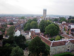
 Warwick z lotu ptaka | |
| Państwo | |
|---|---|
| Kraj | |
| Hrabstwo | |
| Dystrykt | |
| Populacja (2011) • liczba ludności |
|
| Nr kierunkowy | 01926 |
| Kod pocztowy | CV34, CV35 |
Położenie na mapie Warwickshire Contains Ordnance Survey data © Crown copyright and database right, CC BY-SA 3.0 | |
Położenie na mapie Wielkiej Brytanii (c) Karte: NordNordWest, Lizenz: Creative Commons by-sa-3.0 de | |
| Strona internetowa | |
| Portal | |
Warwick (/ˈwɒrɪk/) – miasto i civil parish w Anglii, w regionie West Midlands, stolica hrabstwa Warwickshire, w dystrykcie Warwick[1]. Położone nad rzeką Avon, 18 km (11 mil) na południe od Coventry i 4 km (2,5 mili) na zachód od Royal Leamington Spa. Według spisu powszechnego z 2011 r. civil parish zamieszkiwało 30 114 osób[2].
W mieście Warwick rozwinął się przemysł energetyczny (National Grid), wysokiej technologii (IBM) oraz spożywczy. Warwick jest wspomniana w Domesday Book (1086) jako Waru(u)ic[3].
Atrakcje turystyczne:
- coroczny cykl festiwali, obejmujący m.in. "Spoken Word to Classical and Contemporary Music", "Folk Festival" i "Victorian Evening" (przełom listopada i grudnia)
- Zamek w Warwick – średniowieczny zamek
Miasta partnerskie
 Saumur, Francja
 Verden, Niemcy
 Warwick, Nowy Jork, USA
 Warwick, Rhode Island, USA
 Warwick, Australia
Przypisy
Linki zewnętrzne
- http://www.visitwarwick.co.uk/ - Centrum Informacji Turystycznej
- http://www.warwickdc.gov.uk/wdc - Strona Dystryktu Warwick
- http://www.warwick.ac.uk - Uniwersytet Warwick
Media użyte na tej stronie
(c) Karte: NordNordWest, Lizenz: Creative Commons by-sa-3.0 de
Location map of the United Kingdom
Flag of England. Saint George's cross (a red cross on a white background), used as the Flag of England, the Italian city of Genoa and various other places.
The flag of Navassa Island is simply the United States flag. It does not have a "local" flag or "unofficial" flag; it is an uninhabited island. The version with a profile view was based on Flags of the World and as a fictional design has no status warranting a place on any Wiki. It was made up by a random person with no connection to the island, it has never flown on the island, and it has never received any sort of recognition or validation by any authority. The person quoted on that page has no authority to bestow a flag, "unofficial" or otherwise, on the island.
Autor: Gernot Keller, www.gernot-keller.com, Licencja: CC BY 3.0
Great Britain, Warwick Castle
Contains Ordnance Survey data © Crown copyright and database right, CC BY-SA 3.0
Map of Warwickshire, UK with the following information shown:
- Administrative borders
- Coastline, lakes and rivers
- Roads and railways
- Urban areas
Equirectangular map projection on WGS 84 datum, with N/S stretched 160%
Geographic limits:
- West: 2.10W
- East: 1.10W
- North: 52.70N
- South: 51.94N
Warwick Castle, Warwick, England. Photo also shows the River Avon. A misty October day in 2007.
Warwick pronunciation
Autor: Oryginalnym przesyłającym był Mfield z angielskiej Wikipedii, Licencja: CC BY 2.5
St. Mary's church in Warwick, UK
the tower as viewed from the top of Warwick Castle
taken and uploaded by Matthew Field http://www.mattfield.comEast Gate, Warwick, England. This and the West Gate are the only remnants of Warwick's former medieval town walls.


