Warwick (dystrykt)
| dystrykt niemetropolitalny | |
(c) David Stowell, CC BY-SA 2.0 Royal Leamington Spa | |
| Państwo | |
|---|---|
| Kraj | |
| Region | |
| Hrabstwo | |
| Siedziba | |
| Powierzchnia | 282,9 km² |
| Populacja (2011) • liczba ludności |
|
| • gęstość | 490 os./km² |
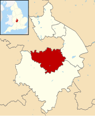
Położenie na mapie Warwickshire | |
| Strona internetowa | |
| Portal | |
Warwick – dystrykt w hrabstwie Warwickshire w Anglii. W 2011 roku dystrykt liczył 137 648 mieszkańców[1].
Miasta
- Kenilworth
- Royal Leamington Spa
- Warwick
- Whitnash
Inne miejscowości
Baddesley Clinton, Baginton, Bubbenhall, Budbrooke, Bushwood, Chadwick End, Cubbington, Hatton, Lapworth, Offchurch, Radford Semele, Sherbourne, Stareton, Stoneleigh, Weston under Wetherley.
Przypisy
- ↑ Area: Warwick (Local Authority). Neighbourhood Statistics (ONS). [dostęp 2016-04-17]. [zarchiwizowane z tego adresu (2016-09-27)]. (ang.).
Media użyte na tej stronie
Flag of England. Saint George's cross (a red cross on a white background), used as the Flag of England, the Italian city of Genoa and various other places.
(c) David Stowell, CC BY-SA 2.0
Bath Street, Royal Leamington Spa. Looking NNW up Bath Street from the edge of the square at the railway bridge. Victoria Terrace can be seen in the distance and the top of the clock tower of the Town Hall is just visible over the roof tops near the centre of the picture. See also 41594
Autor:
- Warwickshire UK district map (blank).svg: Nilfanion, created using Ordnance Survey data
- derivative work: Renly (talk)
Map of Warwickshire, with Warwick highlighted.


