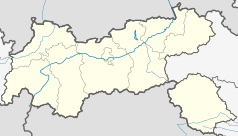
Weißenbach am Lech
| |||
 | |||
| |||
| Państwo | |||
| Kraj związkowy | |||
| Powiat | Reutte | ||
| Powierzchnia | 81,85 km² | ||
| Wysokość | 885 m n.p.m. | ||
| Populacja (1 stycznia 2015) • liczba ludności | 1274 | ||
| • gęstość | 16 os./km² | ||
| Numer kierunkowy | 05678 | ||
| Kod pocztowy | 6671 | ||
| Tablice rejestracyjne | RE | ||
| Strona internetowa | |||
Weißenbach am Lech – gmina w Austrii, w kraju związkowym Tyrol, w powiecie Reutte. Liczy 1274 mieszkańców (1 stycznia 2015)[1].
Zobacz też
- Weißenbach
Przypisy
Media użyte na tej stronie
Autor: Lencer, Licencja: CC BY-SA 3.0
Location map of Austria
Equirectangular projection, N/S stretching 150 %. Geographic limits of the map:
- N: 49.2° N
- S: 46.3° N
- W: 9.4° E
- E: 17.2° E
Blazon:„Vert, ahead a flanche wavy Argent and rear a unicorn rampant Argent.“
The arms were officially granted on September 11, 1979. The unicorn in the arms is taken from the arms of the former court of Aschau, to which the municipality belonged. The white flank is canting (weissenbach means white river/stream).
View on Weißenbach am Lech (Tyrol, Austria), seen from the Landesstraße B 199
Autor: Rosso Robot, Licencja: CC BY-SA 3.0
Location map of The Tyrol
Equirectangular projection. Geographic limits of the map:
- N: 47.75317° N
- S: 46.64119° N
- W: 10.08236° E
- E: 12.98961° E


